HOME >> CHINA
Weeklong campaign to boost citizens’ knowledge of national map
By Dong Feng Source:Global Times Published: 2019/9/1 18:01:06
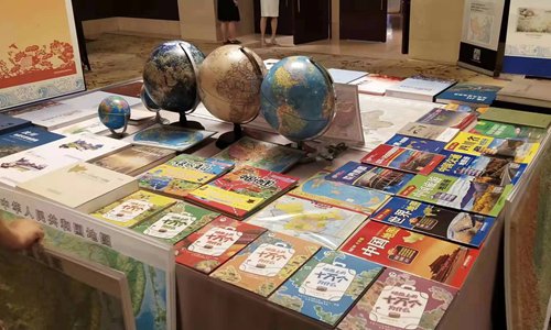
Books, globes and maps are displayed at an activity held by the Chinese Ministry of Natural Resources on Thursday to raise the public's awareness of national territory. Photo: Courtesy of Gu Yekai
China has organized a weeklong publicity campaign to promote people's knowledge of the national map and awareness of national territory, starting from August 29 to September 5.
National territory is the domain in which a country exercises sovereignty and has the right of jurisdiction. It also represents a country's sovereignty as well as its political and diplomatic stance in the international community, according to the Xinhua News Agency.
Thursday marks the 16th publicity day of the Surveying and Mapping Law. This year's theme is "Regulate the usage of maps, no dot on it can be mistaken." The standard maps in 2019 were also released on Thursday, according to www.gov.cn.
China's Ministry of Natural Resources (MNR) plans to jointly hold a series of activities with relevant departments in many places across China to strengthen the awareness of national territory, according to MNR.
A total of 269 standard maps were released on Thursday, including 209 maps of China and 51 of the world, according to www.gov.cn.
"The national map is as solemn as the national flag, national emblem and national anthem. Nothing is too small to matter in a map," Chen Huixian, an official from the map technical review center under the MNR, was quoted by the China Youth Daily as saying.
Some problematic maps contain political errors, including wrongly drawing national borders and marking China's territory into other countries' domain; missing important islands such as the South China Sea islands, Diaoyu Islands and Chiwei Islet; marking Taiwan and Tibet as independent countries; have contents on disputed areas that do not comply with China's relevant regulations, according to the China Youth Daily.
Another mistake involves confidentiality - marking contents that are sensitive or inappropriate to publicize; or marking confidential information.
Raising awareness
Ge Yuejing, a professor at the School of Geography at Beijing Normal University, told the Global Times that national map education should be included in ideological and political education as well as geography classes.
The part in the ideology courses should focus on sovereign integrity and homeland security, and geography classes should offer students a complete picture of national boundaries, Ge said.
"Students need to master knowledge of the national map, which is part of patriotic education. This concept has been promoted in cities in Qingdao and Chengdu, and should be applied across the country," Ge said.
As a committee member of the Chinese Society for Geodesy Photogrammetry and Cartography, Ge proposed the campaign to promote the awareness of national territory in 2017.
In recent years, departments under the State Council have made efforts to raise awareness of the national map in education.
They have held national-level map contests for children and launched a campaign to investigate and rectify problematic maps, according to thepaper.cn.
Four years ago, Ge offered optional courses in Beijing Normal University on the national map. Some of her students told Ge that they should have had this knowledge of the national map earlier.
Problems persist
However, with the increasing use of various types of maps, problematic maps such as those with incorrect borders and missing important islands still exist and spread rapidly. Such map contents are inappropriate and damage national sovereignty, security and interests, thepaper.cn reported.
A total of 307,000 products which contain problematic maps were seized or withdrawn in 2017 and 330 cases of violations were filed, according to the China Youth Daily.
In early August, netizens found that the popular TV series Go Go Squid used a map that did not indicate the island of Taiwan, Hainan Province, South Tibet and Aksai Chin - a region between Southwest China's Tibet Autonomous Region and Northwest China's Xinjiang Uyghur Autonomous Region - as part of China, chinanews.com reported.
Cases of foreign companies using problematic maps have frequently occurred.
For example, MAC Cosmetics apologized in March for posting a map of China that omitted the island of Taiwan in a promotional email campaign to its customers in the US.
"Every time I see those maps of China produced by European and American countries, I feel China's sovereignty has been violated because they intentionally or unintentionally misrepresent China's national borders and missed out the important islands of China and the South China Sea," Ge noted.
Ge pointed out that there are two major reasons for these errors - some Chinese do not have a strong awareness of the national sovereignty and in some cases the materials have been monopolized by multinational corporations.
"Maps and politics have become inseparable. National territory represents national sovereignty and territorial integrity. It embodies a country's political position and should become an important part of citizens' awareness," she said.
China notified 29 Fortune 500 companies to rectify online maps that incorrectly portrayed China's territory in the first half of 2019, according to a MNR release on August 2.
Newspaper headline: No part left out
RELATED ARTICLES:
Posted in: IN-DEPTH,CHINA FOCUS