East China cities brace for typhoon Haikui
| Editor's Note |
Tyhoon Haikui has strengthened into a severe tropical storm and is approaching the coastal area of East China's Zhejiang Province.
Haikui will be the third typhoon to wallop China's eastern coasts in a week after two powerful storms -- Saola and Damrey -- smashed the regions over the weekend. It will be the the first typhoon to make a landfall in the city since 2006.
| Latest News |
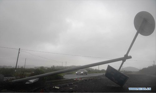
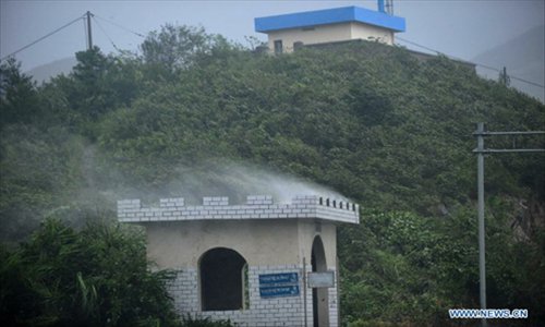
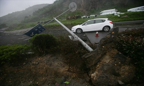
Tayphoon Haikui lands in Zhejiang early August 8. The meteorological department in Zhejiang raised the typhoon alarm to red, the highest level in the afternon on August 7. The Shanghai Meteorological Bureau also raised the typhoon alarm to red, at 11 am on August 8. The following photos depicting the typhoon Haikui are all from the Xinhua News Agency, to see more, click here.
 |
 |
 |
 |
 |
 |
 |
Typhoon Haikui has brought downpours and floods to east China after landing in Zhejiang Province. To see more photos, click here |
 |
Provincial authorities have evacuated 1.8 million people in preparation for the storm.To see more photos, click here |
| Emergency Plans |
Authorities in East China are making full preparation against Typhoon Haikui which has strengthened into a severe tropical storm and is approaching the coastal area of east China's Zhejiang Province.
The circular said that civil affairs offices in Shanghai, Jiangsu, Zhejiang, Anhui and Fujian, as well as disaster relief material reserves in cities such as Hefei and Fuzhou, should be prepared to cope with the typhoon.
Civil affairs offices at all levels should boost their cooperation with other local departments, including meteorological centers, oceanic administrations and resources departments, and keep a close eye on flooding caused by the tropical storm, the circular said.
It also stressed that related departments should use text messaging, electronic signs, broadcast media, TV programs and the Internet to release disaster warnings, disaster prevention information and emergency first aid tips to the public in a timely manner.
Disaster relief material reserve departments should strengthen coordination with local railway and transportation departments in order to ensure that the materials arrive in disaster-hit areas in a safe and timely manner, the circular said. To see more, click here
Source: Xinhua
| Emergency Response |
China has initiated an emergency response and early-warning plan for disaster relief in order to cope with the severity of typhoon Haikui, according to a circular issued by the National Commission for Disaster Reduction on August 6.
In this 6:00 am, August 7, the Central Meteorological Office issued an orange warning for this 11 th typhoon "Haikui". The eye of Haikui located in the sea areas of East China Sea, about 330 km from southeast of Xiangshan County, Zhejiang Province (27.5 N°, 124.4E°). The maximum wind force is up to scale 12 (33 m/s) with the minimum air pressure of 970 hPa.
In this 8:30 am, August 7, Zheng Guoguang, Administrator of China Meteorological Administration (CMA) signed an order to upgrade the emergency response level for typhoon Haikui from Level Ⅲ to Level Ⅱ,the second-highest level in the country's four-tier emergency response system.
CMA urges its internal bodies and institutions concerned to enter Level Ⅱ emergency response immediately. Meteorological departments of Zhejiang, Shanghai and Jiangsu also entered into the Level Ⅱ emergency response state.
Zhejiang is already beginning to feel the effects of the typhoon, and the local Meteorological Bureau has issued a red tide alert, the highest warning on the scale.
Source: Xinhua
| Photo Gallery |
| Affected Areas |
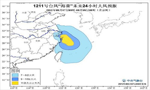
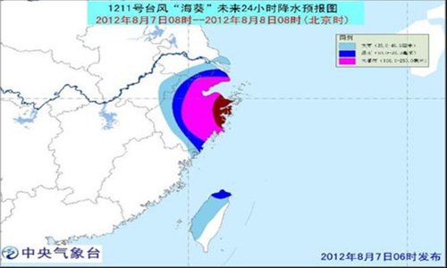
Influenced by Haikui, there will be scale 7 to 9 wind force in east sea areas of Taiwan, northern Taiwan Strait, East China Sea, northern coastal areas of Taiwan and Fujian, eastern and coastal areas of Zhejiang, Hangzhou Bay, mouth of Yangtze River, Shanghai, southeastern and coastal areas of Jiangsu. Meanwhile, the wind force of areas which near the eye of Haikui will be scale 12-13 even 14-15.Moreover, heavy rain to rainstorm will hit most areas of Zhejiang, Shanghai, southeastern Jiangsu, southeastern Anhui, central and western Taiwan while central and Zhejiang, southern Shanghai get severe rainstorm with 250-350mm of rainfall.
Source: Xinhua
| Forecast of Typhoon Haikui |
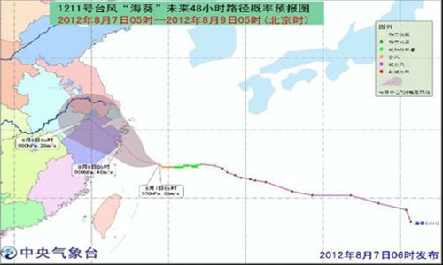
The eye of this 11 th typhoon "Haikui" located in the sea areas of East China Sea which was about 330 km from southeast of Xiangshan county, Zhejiang Province (27.5 N°, 124.4E°). The maximum wind force is up to scale 12 (33 m/s) with the minimum air pressure of 970 hPa.
Haikui will move west by north and then turn northwest at the speed of 10-15 kilometers per hour with gaining intensity and land in the coastal arewas between Zhoushan and Yuhuan of Zhejiang Province in this night to next forenoon.
| Typhoon Damrey and Saola |
Before the approaching Haikui, typhoons Damrey and Saola, which made landfalls in east China on August 3, had caused severe and widespread damage in seven, mostly coastal provinces in China, according to a statement from the National Commission for Disaster Reduction and the Ministry of Civil Affairs on August 5.
The typhoons had left eight people dead and eight missing and forced the evacuation of about 1.3 million residents in provinces of Jiangsu, Zhejiang, Fujian, Jiangxi, Shandong, Hebei and Liaoning as of 9 am, August 5, according to the statement.
Source: Xinhua