China launches another two Beidou navigation satellites
Source:Globaltimes.cn Published: 2012-9-19 14:19:00
| Editor's Note |
More Information:
China's Beidou system starts service in Asian-Pacific
Two more satellites launched for GPS
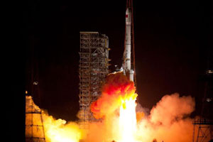 |
China successfully launched another two satellites into space for its indigenous global navigation and positioning network at 3:10 am Beijing time September 19, 2012. They were the 14th and 15th satellites for the Beidou, or Compass, system. The satellites, launched from the Xichang Satellite Launch Center in southwest China's Sichuan Province, were boosted by a Long March-3B carrier rocket. |
| Development of China's Satellite Navigation System |
| China began to build its Beidou Navigation Satellite System in 2000 with a goal of breaking its dependence on the US Global Positioning System (GPS) and creating its own global positioning system by 2020. | ||
| Satellite |
Date |
System |
| Beidou-1A |
October 31, 2000 |
Beidou-1 |
| Beidou-1B |
December 21, 2000 |
|
| Beidou-1C |
May 25, 2003 |
|
| Beidou-1D |
February 3, 2007 |
|
| Beidou-1 can not meet growing demand, so China decided to set up a more functional Beidou-2 regional and global navigation system |
||
| Compass-M1 |
April 14, 2007 |
Beidou-2 |
| Compass-G2 |
April 15, 2009 |
|
| Compass-G1 |
January 17, 2010 |
|
| Compass-G3 |
June 2, 2010 |
|
| Compass-IGSO1 |
August 1, 2010 |
|
| Compass-G4 |
November 1, 2010 |
|
| Compass-IGSO2 |
December 18, 2010 |
|
| Compass-IGSO3 |
June 10, 2011 |
|
| Compass-IGSO4 |
July 27, 2011 |
|
| Compass-IGSO5 |
December 2, 2011 |
|
| China's Beidou Navigation Satellite System officially went into service on December 27, 2011, signaling a reduced dependency on the US Global Positioning System (GPS) and the arrival of a possible future market rival. More |
||
| Compass-G5 |
February 25, 2012 |
|
| Compass-M3/Compass-M4 |
April 30, 2012 |
|
| Compass-M5/Compass-M6 |
September 19, 2012 |
|
Chinese navigation system to cover Asia-Pacific this year Home-bred Beidou Satellite Navigation System (Beidou), will first cover the Asia-Pacific region in 2012, and spread on to global coverage by 2020, said Sun Jiadong, academician and chief designer of the Beidou project. |
||
Source: Beidou.gov.cn
| Application |
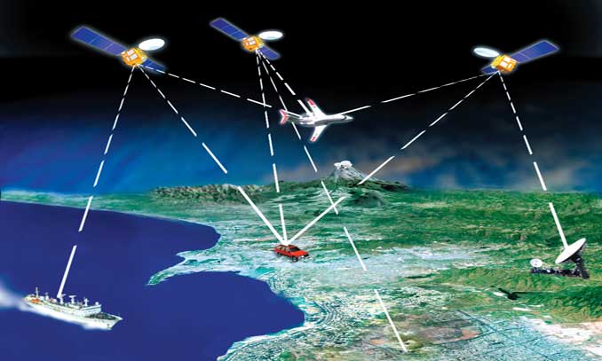 An illustration to the function of China's Beidou Navigation Satellite System. Photo:Beidou.gov.cn |
 The system has been used in transportation, weather forecasting, marine fisheries, forestry, telecommunications, The system has been used in transportation, weather forecasting, marine fisheries, forestry, telecommunications, hydrological monitoring and mapping. The Beidou-1 system made its public debut in the 2008 Wenchuan earthquake. Disaster relief troops used terminals in the ruins of Wenchuan to get real-time whereabouts and communicate with their superiors.As of October 2009, all Chinese border guards in Yunnan are equipped with BeiDou-1 devices.A total of 10,000 government cars in Guangdong Province were required to be equipped with the Beidou navigation satellite system before August 31, 2011 for better supervision and management, the Southern Daily reported.Source: Xinhua |
| Competitors |
| Its competitors include the world-leading GPS system, Russia's GLONASS system, which is also ready for service, and Europe's Galileo, which is still under development. |
|||
| GPS | GLONASS |
Galileo |
|
| The Global Positioning System (GPS) is a space-based satellite navigation system that provides location and time information in all weather, anywhere on or near the Earth. It is maintained by the United States government and is freely accessible to anyone with a GPS receiver. | GLONASS is a radio-based satellite navigation system operated for the Russian government by the Russian Aerospace Defence Forces. |
Galileo is a satellite navigation system currently being built by the European Union (EU) and European Space Agency (ESA). |
|
| Importance |
 More than 5,000 Chinese firms and organizations were now involved in the application and services of satellite navigation and the industry generated more than 50 billion yuan of output value in 2010, according a report published by the Social Sciences Academic Press. MoreRan Chengqi, director of the China Satellite Navigation Office, did not shed light on Beidou's possible military uses, but said without an independently established and operated navigation satellite system, China would lack a reliable safeguard for its economic and social development. He noted that the Beidou system will highlight China's status as a great nation and reflect its comprehensive national power. More
Posted in: Air & Space