HOME >> LIFE, METRO SHANGHAI
Remnants of a city's dreams
By Zhang Yu Source:Global Times Published: 2013-7-10 17:18:01
The Jiangwan Stadium, once part of the Greater Shanghai scheme Photo: CFP
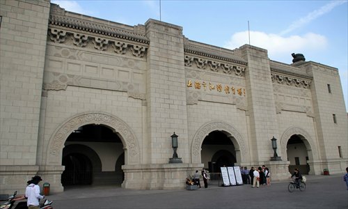
If you visit the Shanghai University of Sport on Changhai Road in Yangpu district, the first building you'll see upon entering the campus is a grand 1930s four-story Chinese palace. For architects and design experts, this building does not exactly belong in Shanghai. Shanghai buildings of this era are usually smaller and have the distinctive southern architectural design style.
A long flight of stone steps, guarded by a pair of lions, leads to the second floor, where six formal red pillars flank a traditionally-patterned interior. The roof stands out from other buildings in the city with its green ceramic tiles. The students here like to refer to it as "the green-tiled building." Back in the 1930s, it had a different name: the City Hall of Greater Shanghai.
The palace, which seems out of place in Shanghai, came about as a result of an ambitious plan by the Kuomintang government to build a new civic center in its northeastern corner — one that would rival the then current city center in Huangpu district, which was ruled by foreigners and dominated by foreign architecture.
A village transformed
From the late 19th century till the 1920s, the foreign administrators in the city's concessions had, using modern urban planning and city management techniques, successfully transformed Shanghai from a small village into a densely-populated modern metropolis and an eclectic center of different architectural styles. Located on the upper reaches of the Huangpu River, the concessions had also become Shanghai's traffic hub, controlling the treaty ports in Shanghai and overseeing water transportation near the city.
In contrast was the underdevelopment of the Chinese section, where the streets and buildings remained largely unchanged and lagged far behind the foreign counterparts. Ding Wenjia, the governor of Shanghai's Chinese areas in 1926, said, "Walking from the International Settlement to the Chinese sections of Shanghai is like passing a river of life and death. If the concessions were a mortal world, the Chinese sections would be called the nether world. Poor roads, shabby architecture and bad hygiene … nothing in the Chinese sections can compare with anything in the settlement."
Although the concessions and the treaty ports were conduits for the ideas and technology that helped modernize China, they were also the nation's great shame and represented a colossal loss of face for a proud, ancient culture. Ding said, "For Chinese people, this is the worst shame, even worse than losing sovereignty of our country."
The nationalists in the country decided to alter the situation and reclaim Shanghai. In April 1927, the Kuomintang established a new national government in Nanjing and raised the official status of Shanghai from the level of a county to that of a city. The first Shanghai municipal government was established on July 14, 1927 under mayor Huang Fu and a municipal council.
A model city
On July 7, Chiang Kai-shek, the president of the Republic of China (1912-49), visited Shanghai to attend the city's founding ceremony. He said, "Shanghai is the first special city in East Asia. It should be the model of China's military, economic and traffic development. If Shanghai doesn't work out, then China will have little future."
The municipality of Greater Shanghai theoretically covered 82.87 hectares, including land on both sides of the Huangpu River. It surrounded the foreign concessions in the city center, which covered a total of 3.27 hectares and remained outside its control.
In 1929, the City Planning Commission was formed, and mayor Zhang Qun and the commission laid out a bold new scheme for reclaiming Shanghai. Later named the "Greater Shanghai Plan," it called for a new administration center on a 4 square-kilometer section of land in the then Jiangwan district, north of Suzhou Creek and the foreign settlements.
Jiangwan offered a number of advantages. It was relatively undeveloped at the time, with room for growth, while older districts such as Nanshi and Zhabei, were too populated to undergo a massive reconstruction. It was served by a major rail line and was close to the Yangtze River port town, Wusong. There, a complex of new basins, piers and wharves would be developed to replace Shanghai's aging port infrastructure, thus making Jiangwan the new center of economic activities in the city. In real and symbolic terms, the "Greater Shanghai Plan" intended to shift the focal point of Shanghai away from the international settlements and form the nucleus of a reclaimed Chinese metropolis.
The plan also echoed the one envisaged by the political revolutionary and founding father of the Kuomintang Sun Yat-sen. Sun wrote in 1922 in The International Development of China: "Although Shanghai is already the largest port in all China, as it stands it will not meet the future needs and demands of a world harbor." Sun proposed that a new world port should be built in or near Shanghai.
Influential architect
The centerpiece of the Greater Shanghai Plan was its civic center, designs for which were solicited in a public competition. In its final draft, the plan called for a cruciform civic center, laid out much along the lines of classic European cathedral. Two grand 60-meter-wide boulevards crossed each other forming a large square with a pagoda in its center.
To the north was the main administrative complex, capped by the City Hall. From there another two boulevards radiated north on either side of the Sun Yat-sen Memorial Hall and Auditorium. Malls to the east and west of the pagoda square, each with parallel lawns and a central ornamental pond, were flanked by government department offices; the longer mall to the south featured a library, museum, art gallery, concert hall and a five-arched ceremonial arched gate (pailou) at the entrance.
Each of the malls was capped by a semicircular road, beyond which the city was laid out in a simple linear grid of blocks. The homes of successful businessmen and officials were situated close to parks on either side of the central axis, and these were surrounded in turn by neighborhoods for workers.
Naming system
The roads in the civic center were named after a special system - all the roads there began with one of the characters Zhong, Hua, Min, Guo, Shang, Hai, Shi, Zheng or Fu. Together in Chinese the characters spell out "the Republic of China, Shanghai municipal government." Most of the roads today still bear their original names.
According to the plan, a commercial district was located near the new harbor at Wusong, while a sports complex would be built just west of the civic center. An airport was constructed in the east, close to the Huangpu River.
The civic center buildings themselves utilized the so-called Chinese Renaissance style, a combination of Chinese Ming Dynasty (1368-1644) and modern Western architecture, and were designed by Dong Dayou and Zhao Shen. Both men had worked for the American pioneer of this style, Henry K. Murphy, a Connecticut Yankee whose Chinese portfolio included several college campuses and plans for the then new Chinese capital in Nanjing.
The Greater Shanghai Civic Center employed design philosophies to convey a message of a semicolonized society breaking free of its shackles, reasserting itself and staking a claim on both city and nation.
For a while, it looked as if it all might happen. Between 1931 and 1937, several key structures were built including the dominant City Hall which is now part of the university complex. The Shanghai Municipal Library and Municipal Museum, both also designed by Dong Dayou and Zhao Shen, were added two years after. These were followed by a hospital, a stadium complex, a swimming pool, and a building for the China Air Transport Association.
Given the political turmoil that was engulfing the city, it was astonishing that even these few buildings were completed. Shanghai in the 1930s was in a constant state of terror. Bombings by the Japanese in the spring of 1932 drove tens of thousands of Chinese refugees into the international settlements. On October 10, 1933, an inauguration ceremony for the new City Hall was attended by thousands of Chinese and foreigners, but fate intervened nonetheless. When the Japanese entered Shanghai again in the summer of 1937, there were bloody clashes with Chinese troops in Jiangwan. Eventually, all construction at the civic center came to a halt.
The new Greater Shanghai municipal government fled to the safety of the international settlements, leaving the battered civic center buildings to the invaders when Shanghai fell on November 12, 1937. Japanese troops took over the civic center for the duration of the occupation.
Plan ditched
During the occupation, the stadium became the invaders' arsenal. An arms factory was built on the former lawns and trenches, power lines and fortifications surrounded the area. Even after the Japanese lost the war and left China, the nationalist government stayed on in the old city center, where the concessions had been returned to Chinese rule, and ditched the "Great Shanghai Plan" along with those buildings, now weathered and dilapidated after the war.
Jiangwan would never again be the focus of Shanghai's dreams. The civic center buildings were used instead to house a hodgepodge of cultural and educational institutions over the years.
Once prominent landmarks surrounded by open space, they are now largely lost in a dense thicket of urban construction. The library and art gallery are now in the campus of a middle school, next to a basketball court. The museum, hospital, and the China Air Transport Association building are now part of the Second Military Medical University. And the old City Hall is today offices and classrooms for the Shanghai University of Sport.
Posted in: Tips, Metro Shanghai, Meeting up with old Shanghai