HOME >> LIFE, METRO SHANGHAI
Free flowing history
By Du Qiongfang Source:Global Times Published: 2014-4-7 18:38:01
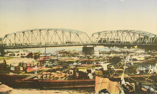
The Waibaidu Bridge in the early 1900s
The two major rivers in Shanghai, the Wusong and Huangpu rivers, have their sources in Taihu Lake in Jiangsu Province, and have played very important roles in the history of Shanghai, helping establish the municipality and seeing it become a key port city in China. But the status of the two rivers has changed over time. The former major waterway, the Wusong River became a minor tributary and was renamed Suzhou Creek, while the Huangpu River, which was once an offshoot tributary of the Wusong River, gradually became the major waterway in Shanghai.The intersection of the destinies of these two rivers is marked by the Waibaidu Bridge, or Garden Bridge, for this is where Suzhou Creek joins the Huangpu River.
Native Shanghainese call the Huangpu River their mother river. It is 113 kilometers in length and between 300 and 700 meters wide, dividing Shanghai into Puxi and Pudong. In contrast, Suzhou Creek, the part of the Wusong River that runs through Shanghai, is only 54 kilometers in length and 40 to 50 meters wide, and for the most part it flows between city roads and buildings through the north section of downtown Shanghai.
History records that the Wusong River was once a vast waterway that in the Tang Dynasty (618-907) matched the Yangtze and the Yellow rivers, while the Huangpu River was just one of its 18 tributaries through which the Wusong River ran into the East China Sea.
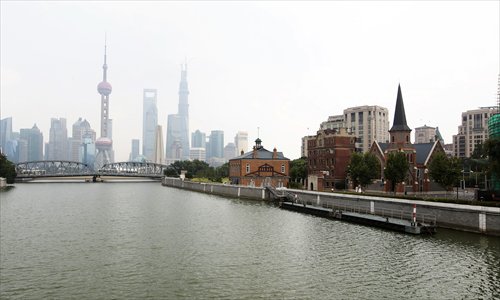
A present-day view of Suzhou Creek Photos: CFP
Major spillwayThe Wusong River became the major spillway for Taihu Lake after its two other branches silted up. It was also the major waterway for Suzhou people to travel to sea. In a downstream area of the river, near the sea, a fishing village quietly developed. Local people used bamboo fish traps called "hu" to fish - this is the origin of the simplified Chinese name for Shanghai.
The village lay to the south of Wusong River, to the east of the Wu county of Suzhou which was the political and financial center of the Taihu Lake region; and to the west of the sea and the north of Huating county (today's Songjiang district). With the economic development of the Taihu region, a port was needed and it was established in the little village which became the area's first foreign trading port, Qinglong town.
Qinglong town was prosperous for some time with boats from Hangzhou, Suzhou, and Huzhou arriving monthly and ships from Korea and Japan berthing annually. Were it not for the silting up of the Wusong River later, which caused the town's decline, Shanghai would probably have developed there in the town that prospered for several hundred years.
The silting of the Wusong River had started in the Song Dynasty (960-1279) with the gradual sinking of the Yangtze River Delta and mud accumulating at the mouth of the river. Wusong River shrank and large ships could no longer reach Qinglong town.
A stream, known as Shanghaipu, from the south bank of the Wusong River, gradually became the major waterway. And a new town developed around the riverbank close to today's Shiliupu. At the end of the Southern Song Dynasty (1127-1279) the township of Shanghai was officially established, but its real importance would not be realized for some time.
In 1403 the Wusong River was blocked and flooded and this completely changed the relationship between the Wusong and Huangpu rivers, as well as spurring the development of Shanghai. Xia Yuanji, a high official from the imperial court, was sent to supervise the flood controls. He believed that the key to controlling the flooding was to dredge the downstream waterway and direct the flow into the sea.
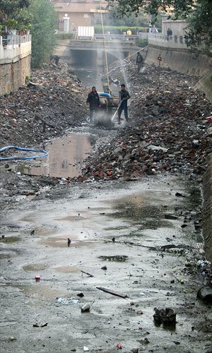
A tributary of the Suzhou Creek, heavily polluted, being cleaned up in 2004
A new routeXia started dredging the Huangpu River between the Waibaidu Bridge and Fuxing Island areas. The waterway widened itself after torrents of water from upstream constantly flushed through the new route to the sea. After that, the Wusong River gradually became a tributary of the Huangpu River. The flooding which saw the Huangpu eventually replace the Wusong River as the major waterway was known as Huangpu duo Song (Huangpu seized the Song). And Shanghai was, from then on, nurtured by the Huangpu River.
On November 8, 1843, General George Balfour led British troops into Shanghai and a week later, he announced the opening up of Shanghai, the forcing of the city to trade with Britain. The British invaders noted immediately the prime area of the city by the rivers and marked off their concession on the west of the Huangpu River, to the east of Xizang Road, and from the south of Suzhou Creek to the north of Yangjingbang, today's Yan'an Road East. The rivers made natural barriers for the concession and offered alternative transport methods for officials and businessmen. The British consulate was built at the mouth of Suzhou Creek.
At that time, most of the area around the river intersection was farmland or swamps. But the river mouth where Suzhou Creek connected with the Bund became the base for modern Shanghai.
The establishment of the British Concession was followed by the American Concession on the north bank of Suzhou Creek in today's Hongkou district; and the French Concession between Yangjingbang Road and the old city (today's City God Temple area). The consulates of Russia, Germany and Japan soon also clustered around the river mouth.
It was then that Suzhou Creek was redefined. When the British and American concessions were combined as the Shanghai International Settlement, Suzhou Creek became the inland river for the concession. Where the Huangpu River was wide and deep, Suzhou Creek was not suitable as a port or industrial zone, so it became a meeting place for residents and a series of small quays. While financial and foreign trade companies set up in the buildings along the Bund, theaters, parks, hospitals and post offices sprang up alongside Suzhou Creek.
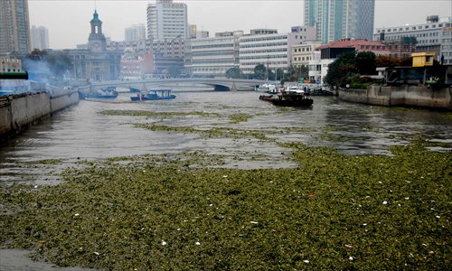
An algae infestation took over parts of Suzhou Creek in 2009.
First bridgeIn 1855, the first modern bridge was erected over Suzhou Creek accelerating the transformation of the river mouth area. Before that, ferries were the only way of crossing the river and if it was dark or there was bad weather no one could cross. A British businessman, Charles Wills, sniffed a business opportunity and built a wooden drawbridge near the ferry wharf at the river mouth in 1856. It was initially called the Wills Bridge and also became known as Waibaidu Bridge (the Outer Ferry Bridge). People who used the bridge had to pay a toll which created resentment among the public.
The bridge was hastily and rather shoddily built and it soon began showing signs of wear. When the municipal committee of the Shanghai International Settlement ordered the bridge be repaired or dismantled Wills refused. So the committee bought it and took it over in 1875, restoring it and putting it back into service. It was renamed the Garden Bridge (it was close to the small park on the Bund). The restored fixed bridge was larger than the original but, in 1906, the municipal committee demolished that wooden structure and built a steel bridge with rails to carry trams. The Waibaidu Bridge was the first steel bridge in Shanghai and has become one of the city's landmarks.
Because it didn't charge tolls it attracted a lot of traffic. Nearby some of the city's early iconic hotels flourished - Astor House (the Pujiang Hotel) and Broadway Mansions (Shanghai Mansions) offered stunning river views.
The foreigners often treated the rivers as if they were the Seine or the Thames and enjoyed water sports or other entertainments on the water. After transforming the way the river was treated they then transformed its name, calling it Suzhou Creek, not the Wusong River, because it took businessmen, missionaries and officials of the day to Suzhou. The name stuck although it is not officially recognized yet by Chinese authorities. Some maps list it as Wusong River (Suzhou Creek).
The difficulties of the past have not hampered the development of Suzhou Creek. The block surrounded by Suzhou Road South, Huqiu Road, Tianchi Road and Zhongshandongyi Road is known as Waitanyuan (the headstream of the Bund) and is now a major tourism area.
There were other bridges - by 1949, along a 3.65-kilometer stretch of Suzhou Creek there were 11 concrete and steel bridges to the east of the Hengfeng Road Bridge. Along the 9.35-kilometer stretch to the west of Hengfeng Road Bridge, there were just six wooden bridges and one iron one - an illustration of the gap between the Chinese sections of town and the foreign areas.
A major controversy erupted in the concessions over a sign apparently erected at the gates of the Bund Park (Huangpu Park) which reportedly read: "Chinese and dogs not admitted." The regulations enforced by the authorities of the day reserved the use of public parks and gardens for the foreign community and dogs and bicycles were not admitted. A wooden sign in Chinese advising that Chinese and dogs were forbidden aroused the ire of the locals and the municipal committee built another park for Chinese near Sichuan Road Bridge. After the 1925 May 30th Movement and protests, Chinese people were admitted to all foreign parks.
Zhabei had been the largest Chinese community and was surrounded by international settlements on three sides before being developed. The development from 1900 saw business and residential zones established and the Shanghai North Railway Station built on Tianmu Road East. The community on the north bank of Suzhou Creek became the most prosperous Chinese area.
Industrial development
Before the development of Zhabei, silk factories, dry docks, lumber mills, a gas plant and piers were built along the middle stretch of Suzhou Creek. At the beginning of the 20th century, there were 17 banks and warehouses along the river which became a center for industry and distribution. After the development of Zhabei, the two banks of Suzhou Creek to the west of Hengfeng Road Bridge were developed further with industries to form the Huxi industrial zone. By 1949, the Huxi industrial zone was home to 1,914 factories.
After 1920, the section of Suzhou Creek between Hengfeng Road Bridge and the mouth of the Wusong River was heavily polluted, murky and foul-smelling. Between 1948 and 1979, the pollution spread through all of Suzhou Creek to Qingpu district. Alongside with the pollution was the arrival of slums for the thousands of migrant workers employed by the factories.
At the end of the 1980s Shanghai began to accentuate the city as an economic force and started relocating industry. Many of the factories on the west of Suzhou Creek were relocated and following this the workers were also moved and the slums torn down and redeveloped.
Between 1988 and 2000, a pollution control project began cleaning up the waterway and fish started reappearing.
Posted in: Miscellany, Metro Shanghai