On livestock and fishing boats, BeiDou navigation system finds increasing civilian use
BeiDou, China's domestically built navigation satellite system, that was originally designed to be a military tool, has gradually entered many aspects of daily life. Striving to seize the initiative and enter a market dominated by GPS, which is controlled by the US department of defense, China is ambitious to make BeiDou a new global brand.
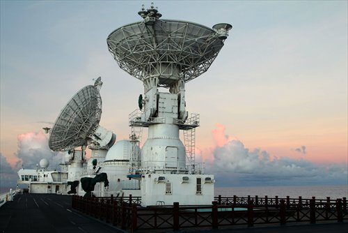
Signal receivers on one of China's satellite monitoring ships track the launch of the 21st BeiDou satellite in the Southern Pacific on February 1. Photo: IC
Li Runsheng, a 40-year-old herder from the Inner Mongolia Autonomous Region, has hundreds of sheep spread across the vast grasslands of the region.
But he knows where most of them are at any moment, because many wear collars that send a signal to Chinese-built satellites. The control that the BeiDou Navigation Satellite System (BDS) chips gives him has revived his prospects of success.
"The collars can not only help us give each animal a unique identification number and trace them reliably, but can also tell us which sheep have reached slaughter age," Li, from Urad Front Banner, Bayannur City, Alxa League, told the Global Times.
He established a sheep farming cooperative with four partners several years ago. He is one of the only two who have stuck with the business though, as sales were poor. "It's hard to convince urban consumers that our sheep are really raised cage-free in pastures in Alxa," Li explained.
Alxa mutton is famous for its tenderness, as non-Alxa meat is often falsely labeled as being from the region.
This year Li has cooperated with Ala Farm, a firm which has attempted to build bridges between China's herdsmen and consumers, and now more than 1,000 of his sheep are wearing BDS collars.
According to Ala Farm founder Guo Zhiguo, they can provide consumers with real-time visual information concerning the livestock's movement and growth with the help of BDS and drones. Likewise, herdsmen like Li can use this technology to monitor his animals from his mobile phone or a tablet computer.
Li is just one of many who have already benefited from BDS, a domestically developed global navigation satellite system which officially started to offer civilian services in certain regions in 2012.
From tractors planting seeds in Northwest China's Xinjiang Uyghur Autonomous Region, to tracking devices used by law enforcement officers, a dam monitoring system in Quanzhou, East China's Fujian Province, to a smart home-care system for seniors living in Anyang, Central China's Henan Province, BDS has begun to seep into almost every aspect of modern life.
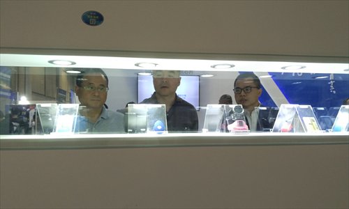
Visitors check out BeiDou-enabled devices at the 7th China Satellite Navigation Conference in Changsha, Hunan Province on May 18. Photo: Huang Jingjing/GT
Origin
In 2000, feeling anxious about its reliance on foreign-controlled satellite systems, China set up the BeiDou navigation test system, making China the third country to develop such a system after the US and Russia.
One major cause of this anxiety was the worry that in the case of a US-China conflict, the US would block China from using the GPS system and leave the country at a major disadvantage.
BDS, built by the State-owned China Aerospace Science and Technology Corp, aims to provide positioning, navigation and timing services globally by 2020. The civilian service is provided free of charge, with a current positioning accuracy of 10 meters, according to beidou.gov.cn. After the building of ground stations to enhance BDS signals nationwide, the accuracy will grow to be within 1 meter in China, according to reports.
Thanks to government funding and subsidies, as well as its market potential, civilian uses of BDS have thrived in China in recent years. According to media reports, BDS has already been widely applied to farming, meteorology, transportation, fishing, public security and disaster relief.
In a speech made at the 7th China Satellite Navigation Conference held in May in Changsha, Central China's Hunan Province, Zhu Fugang, an official from the Ministry of Public Security said that more than half of Chinese police's tracking devices now use BDS, with the proportion set to increase.
The number of daily BeiDou users has surpassed 10 million, according to Tan Shusen, who worked on BDS, and this figure is expected to triple this year.
Wang Hansheng, vice president of Olink Star, a Beijing-based company that makes navigation satellite system products, revealed to the Global Times that about 30 to 50 million smartphones installed with multi-mode chips that will be compatible with BDS, GPS and Russia's GLONASS are expected to hit the market this year. They will be mainly domestic-made smartphones, such as Huawei, Wang said.
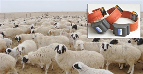
Sheep wait to be collared with tracking devices. Photo: Courtesy of Guo Zhiguo
Two-way street
Currently, there are four Global Navigation Satellite Systems, BDS, GPS, GLONASS and Europe's Galileo. BDS has some design advantages.
Tan said that BeiDou will eventually be able to realize higher accuracy as its service can broadcast on three frequencies, unlike the GPS, which only uses one.
In addition, unlike other systems which only broadcast one-way reference signals, BDS has a two-way communication capability that allows users to send short text messages.
For example, a general can use BDS to send instructions to his soldiers, and fishing boats that break down can call for help without using unreliable mobile phone signals or expensive marine satellite Internet.
"After the signal is received, staff at the operation center will find out whether there are other boats nearby, and then carry out a rescue operation as soon as possible," Zhou Ruxin, member of staff at the Beidou Operation Service Center, was quoted as saying by China Central Television.
According to an article written last year by someone working at a military-industry unit who used the pseudonym "Donnie," sending a short message via BeiDou only costs 0.3 yuan ($0.04), much less than using a satellite telephone.
Donnie cited 2011 statistics that said fishermen in East China's Zhejiang Province sent a total of 13 million short messages through BDS that year.
Guo Zhiguo from Ala Farm explained that the BDS collars they attach to animals send positioning messages automatically more than 20 times a day and the device's battery can last for 16 months.
"Before, we negotiated with a company that used GPS, but their collars cost up to 10,000 yuan. The BDS collars only cost about 80 yuan each," Guo told the Global Times.
He believes that besides helping farmers, they can be of assistance to the government. "The government can have access to the database, so they can easily monitor cattle numbers and respond if the density is too high," he said.
Guo said Ala Farm has helped farmers collar over 1,000 sheep so far. However, he is highly ambitious and expects to one day provide 100,000 collars annually.
"Many herdsmen from Tibet, Qinghai and Xinjiang have approached me and asked to join in," he said.
Finding the path
However, despite its growing popularity, the BeiDou satellite network has some shortcomings.
The performance of the BeiDou System, such as its accuracy, still needs to be improved.
A young man in Beijing told the Global Times that he used a BeiDou wristwatch during a hike about three years ago. "It was disappointing that the data it showed on positioning and altitude were both inaccurate," he said.
However, Ma Deming, an outdoor brand consultant, doesn't think BDS's performance lags much behind GPS today. He co-organized a cross-country run that circled Mount Siguniang, Sichuan Province, in November last year. The organizer put a BDS/GPS dual-mode device on runners, making it the first cross-country running event to use BDS, he said.
"BDS performs well in positioning accuracy and two-way communication. I believe the BDS will have a bright prospect in risk and safety management in activities like wildness exploration, trail running and rescue," Ma told the Global Times.
But Xu Qifeng, an expert on global navigation satellites, pointed out that BDS will face major hurdles to going global.
To increase accuracy and realize global coverage, BDS monitoring stations will need to be established globally.
According to gps.gov, there are 350 GPS monitoring stations in 80 countries, contributing to an international network of navigation services.
"But it's a big challenge for China to build so many monitoring stations overseas," Xu remarked at the 7th China Satellite Navigation Conference, citing the huge cost.
Besides, China's satellite atomic clock technology, which is vital for the accuracy of the system's service, lags behind the US' and Europe's, Xu lamented at a navigation forum in 2012.
Tan said he agrees with Xu. "There's a lot for us to do, such as negotiating with other countries in both diplomatic and civilian means," Tan told the Global Times.
"BDS's general positioning effect is still inferior to GPS's. The terminal chips we've made are diversified and some of them are already small enough, but there is still gap on average," Tan said.
Li Yuan, a senior manager with the MXTronics Corporation, which produced BDS collars to help track Tibetan antelopes in 2013, said the gap is understandable as the GPS has been established for decades.
The space, ground and user stations for BDS are yet to be completely established. When fully deployed, the BDS space network will consist of five Geostationary Earth Orbit satellites, 27 Medium Earth Orbit satellites and three Inclined Geosynchronous Satellite Orbit satellites.
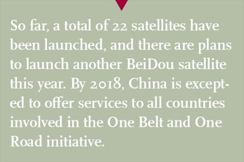
So far, a total of 22 satellites have been launched. Ran Chengqi, director of the China Satellite Navigation Office, said in May that there are plans to launch another BeiDou satellite this year. By 2018, China is excepted to offer services to all the countries involved in the One Belt and One Road initiative.
The other three Global Navigation Satellite Systems are also preparing to expand or update their constellations by launching next-generation satellites.
Li Runsheng is confident about BDS. He is prepared, with BDS's help, to expand his flock.
According to official statistics, the gross revenue from navigation satellites in China reached 190 billion yuan last year, 30 percent of which was contributed by BDS-enabled products.
Newspaper headline: China’s eye in the sky