China launches new 3D mapping satellite
Source:Global Times Published: 2019/11/3 14:27:27
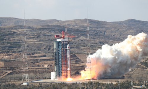
The Gaofen-7 satellite is launched aboard a Long March-4B rocket at the Taiyuan Satellite Launch Center in North China's Shanxi Province on Sunday. Photo: People's Daily App
China on Sunday launched an advanced 3D mapping satellite that can clearly see small country lanes from orbit, and will play a vital role in supporting urban and agricultural development.
Carried by a Long March 4B rocket, the Gaofen-7 satellite was launched from the Taiyuan Satellite Launch Center in North China's Shanxi Province at 11:22 am on Sunday, People's Daily reported.
Three other satellites were launched together with the Gaofen-7, according to the report.
As China's first civilian sub-meter level optical transmission 3D cartographic satellite, the Gaofen-7 will be used in various fields including land mapping, urban and rural development and statistical surveys, and will contribute to the planning of city clusters and development of rural villages, the report said.
The Gaofen-7 is the most accurate scientific research mapping satellite in the Gaofen series and can realize 3D mapping with a scale of 1:10,000, according to the report.
China's previous Ziyuan-3 satellites, which could achieve a mapping scale of 1:50,000, could clearly map highways. By comparison, the Gaofen-7 can accurately locate small country lanes, reads a statement released by the China Academy of Space Technology under the state-owned China Aerospace Science and Technology Corp (CASC), developer of the satellite, on Sunday.
The statement also stressed the 3D capability of the Gaofen-7, noting it is also the only satellite in the Gaofen series capable of taking 3D pictures.
Once in orbit, the Gaofen-7 will form the first optical 3D cartographic satellite constellation together with the two Ziyuan-3 satellites that are already in orbit, said Wang Xiang, chief commander of the Gaofen-7 program.
This will effectively boost Chinese satellites' capability to cover land in 3D and reduce the country's dependence on foreign data, according to Wang.
Posted in: SOCIETY,AIR & SPACE