Netizens, local residents disprove satellite imagery-based accusations on Xinjiang
By GT staff reporters Source: Global Times Published: 2020/8/31 21:58:41
Local residents disprove satellite imagery-based accusations on Xinjiang
A screenshot of Chi's tweet under his authority
A recent article from Buzzfeed News "revealing" more than 300 locations being used as part of an "internment program" in Northwest China's Xinjiang Uygur Autonomous Region has been debunked by netizens and local residents, as the claims, based solely on satellite imagery taken from the outerspace, are a result of wild guessing.
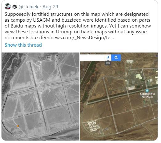
The "report" of Buzzfeed claimed that it used China's Baidu Maps to identify blank locations where it used to find a network of buildings bearing the hallmarks of "prisons and internment camps" in China's Xinjiang. By using satellite imagery, the news site said it identified 428 such locations "bearing the hallmarks of prisons and detention centers" since the summer of 2018, and said it believes "315 are in use as part of the current internment program."
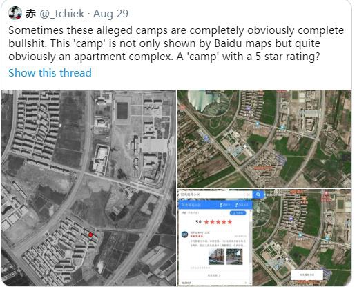
A netizen named Chi found that a spot that the Buzzfeed story claimed to be a "camp" in Shule county of Kashi Prefecture in southern Xinjiang is in fact a residential community. He also found that most locations that Buzzfeed alleges to be "camps" can be found on Baidu Maps.
"The entire premise of this propaganda" is fundamentally flawed, the netizen wrote.
Allison Killing, a contributor of the Buzzfeed story, responded to Chi's questions on her Twitter account, saying that the buildings on the northeastern side of the complex comprise a camp and this "has been corroborated."
However, residents in the community and relevant departments reached by the Global Times in Shule county said there are no training centers in the spot that Killing referred to. No "hallmarks of prisons and internment camps" could be found by the Global Times, using either Baidu Maps or Google Map.
Who Killing claims "corroborated" the existence of the "camp" remains unknown.
When reached by the Global Times, Chi said that Killing claimed to have started the research using Baidu in 2018, and Baidu has removed the light gray tiles that were used to find the "camps" - "Baidu has changed."
"They said Baidu has changed, which cannot be confirmed… anyway, they are not objective [on the topic]," Chi said.
A screenshot of Chi's tweet under his authority
Aside from using "gray tiles" to spot possible camps on map platforms, Buzzfeed said it narrowed the search scale by reasoning that "internment camps" need to be near towns as it is easier for families to visit their loved ones "in custody" and guards' families need to have access to health care, and so on.
Buzzfeed may think its analysis is "sharp" and "intelligent" but it fully exposes how laughable it is when trying to lie, experts said, noting that previous Western media reports claimed that Xinjiang set up "camps" in sparsely populated areas.
This is not the first time that some foreign media and think tanks have used satellite imagery to smear China's Xinjiang or tell stories based on their imaginations or on malicious purposes, observers said.
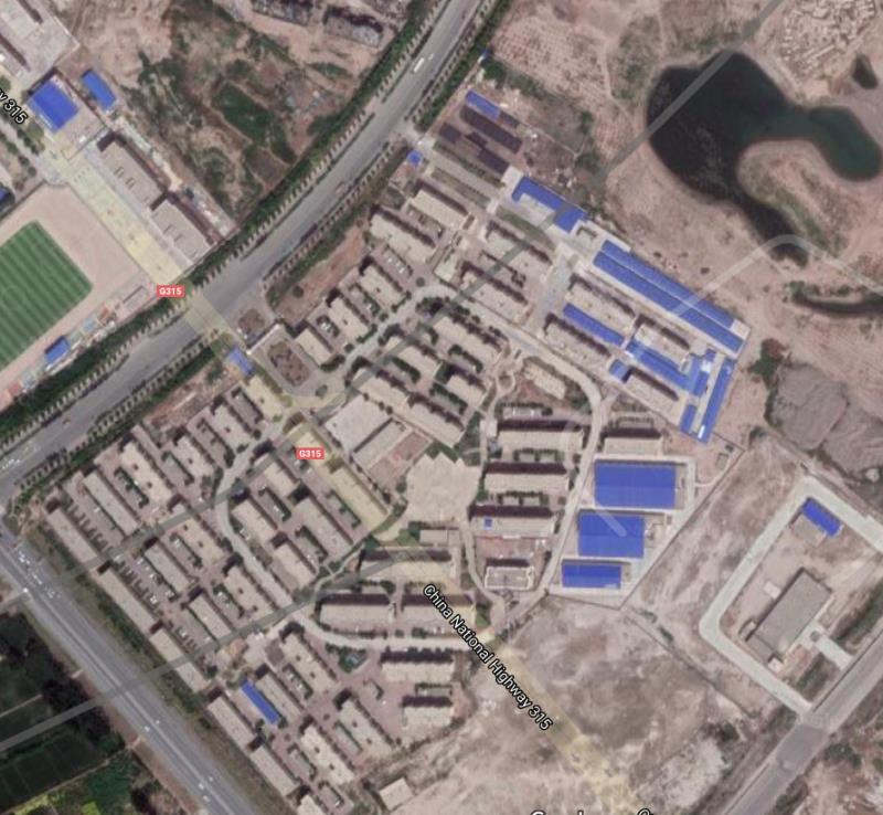
A screenshot of the residential community mentioned in the Buzzfeed story
CNN made a report in January, claiming that more than 100 Uygur graveyards were "demolished by Chinese authorities." The allegation was based on satellite images and a story told by a Uygur living overseas. However, the Global Times went to the spot where the graveyard had been located and found that it was not demolished but moved to a cemetery nearby with a better environment, with the agreement of family members of the deceased.
"Satellite imagery cannot fully reflect the truth as every company in each country has different standards of mapping and gets different authority for access to facilities involving military, commercial or civilian use. It is also imaginary and biased to 'spot' so-called camps by using blank spots or fences shown in satellite images," Zhu Ying, deputy director of the National Human Rights Education and Training Base of the Southwest University of Political Science and Law, told the Global Times.
Zhu noted that without finding solid evidence to support their accusations against China, some Western media organizations have deduced that China is guilty and they use flawed reports as evidence.
"They are using their advantages in outer space and satellites to spy on other countries or make lies against international order and morality. Satellite imagery and other flawed reports anti-China forces make, aim to accomplish the goal of accusing China of oppressing minorities in the region," Zhu said.
The Buzzfeed story made acknowledgements to Adrian Zenz, a notorious anti-China German scholar who made a series of lies to smear China, and the Australian Strategic Policy Institute (ASPI), a "right-wing, militaristic" think tank funded by US and other Western governments, mega-corporations and an eye-popping array of weapons manufacturers.
Newspaper headline: Local residents disprove satellite imagery-based accusations on Xinjiang
RELATED ARTICLES:
Posted in: SOCIETY