ARTS / CULTURE & LEISURE
New section of state-level thoroughfare of Qin Dynasty uncovered, further clarifying route of 2,000-year-old ‘expressway’
By Published: Dec 11, 2025 05:14 PM

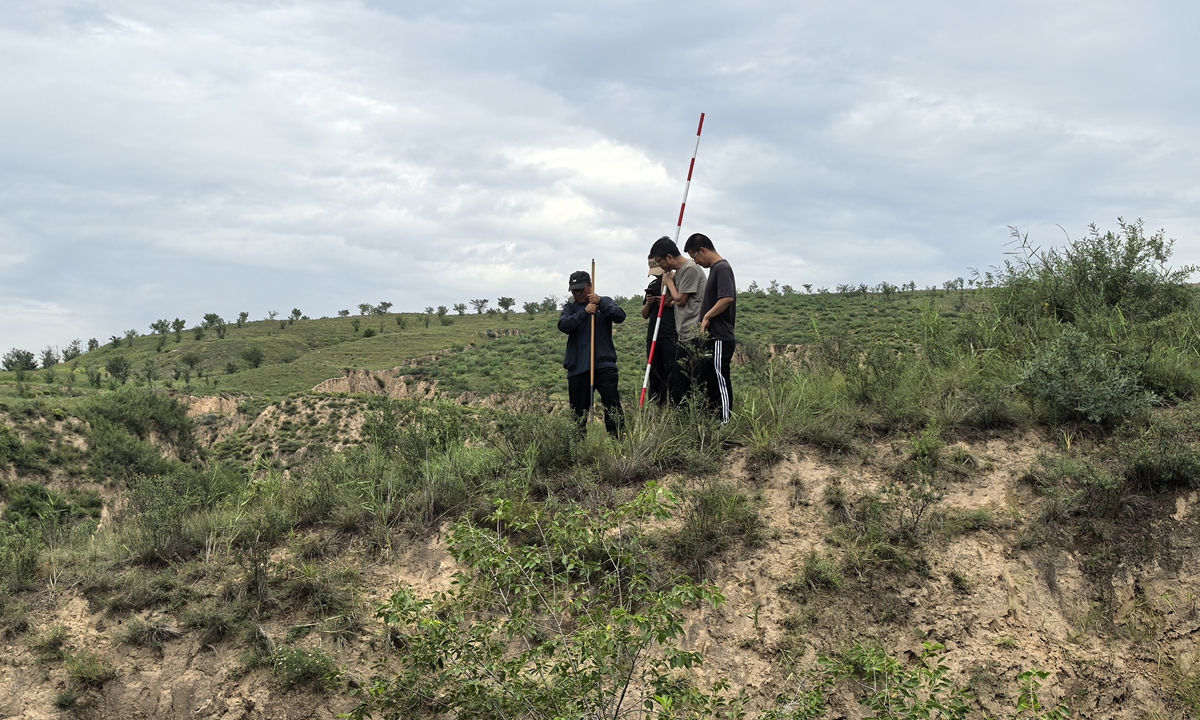
Researchers survey the remains of the road dating back to the Qin Dynasty. Photo: Courtesy of Yulin's institute of cultural relics protection and research
Recently, Chinese archaeologists discovered a newly identified section of a Qin Dynasty (221BC-206BC) path measuring approximately 13 kilometers in length, in Yulin, Northwest China's Shaanxi Province. This key finding provides important archaeological evidence for confirming the overall route of this state-level thoroughfare that was ordered to be built by Emperor Qinshihuang, Lei Qingqing, a researcher at Yulin's institute of cultural relics protection and research, told the Global Times on Thursday.
The thoroughfare, also known as Qin Zhi Dao, was first built in 212BC, starting at Yunyang (today's Chunhua county in Shaanxi Province) in the south and reaching Jiuyuan (now Baotou in North China's Inner Mongolia Autonomous Region) in the north. The construction of the road was one of the famous projects in ancient China. It opened up an "expressway" from the Qin's capital to all parts of the country, especially the northern border, ensuring the rapid movement of troops and the prompt delivery of government orders, Liu Zheng, a member of the Chinese Society of Cultural Relics, told the Global Times on Thursday.
According to Lei, Sima Qian in Han Dynasty (206BC-AD220), the author of Shiji, also known as Records of the Grand Historian, once traversed this road. His chronicles documented the road's construction, which involved excavating mountains and filling valleys to reshape the natural landscape. The route was described as "straight through," representing an enormous engineering feat. This project witnessed numerous major events in Qin and Han history, playing a significant role in China's unification and development, with far-reaching influence.
However, due to the brevity of historical records, the exact route of the road has long been lost to history. For many years, academic circles have debated differing theories, such as the "western route" and "eastern route," with certain sections from Yulin to Ordos in Inner Mongolia Autonomous Region remaining unconfirmed.
The newly discovered section is located precisely in the critical connecting area between the previously confirmed segment in Shaanxi and the segment in Inner Mongolia Autonomous Region. Its straight alignment and construction feature closely resemble those of the confirmed sections in Inner Mongolia, providing strong archaeological support for the "eastern route" theory. "This breakthrough also resolves the long-standing difficulty of pinpointing the route in the central section, adding new evidence for determining the whole alignment of the road," Lei noted.
At the site, the structure of the road can be clearly observed in some cross-sections of ditches. Beneath the topsoil, there are discernible layers: a trampled road surface, compacted subbase, and fill materials. The trampled surface appears in a layered, mille-feuille-like form, generally 11-19 centimeters thick. The compacted subbase and fill are mainly present in low-lying areas and at points where the road crosses gullies, with thickness varying according to the size of the crossing.
For larger gullies, the volume of fill is substantial and the compacted base is thicker, with fill layers interspersed between the tamped earth, resulting in a complex structure that can reach up to about 13 meters of thickness.
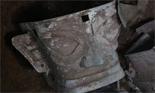
Cultural relics that were discovered along the section of the road Photo: Courtesy of Yulin's institute of cultural relics protection and research
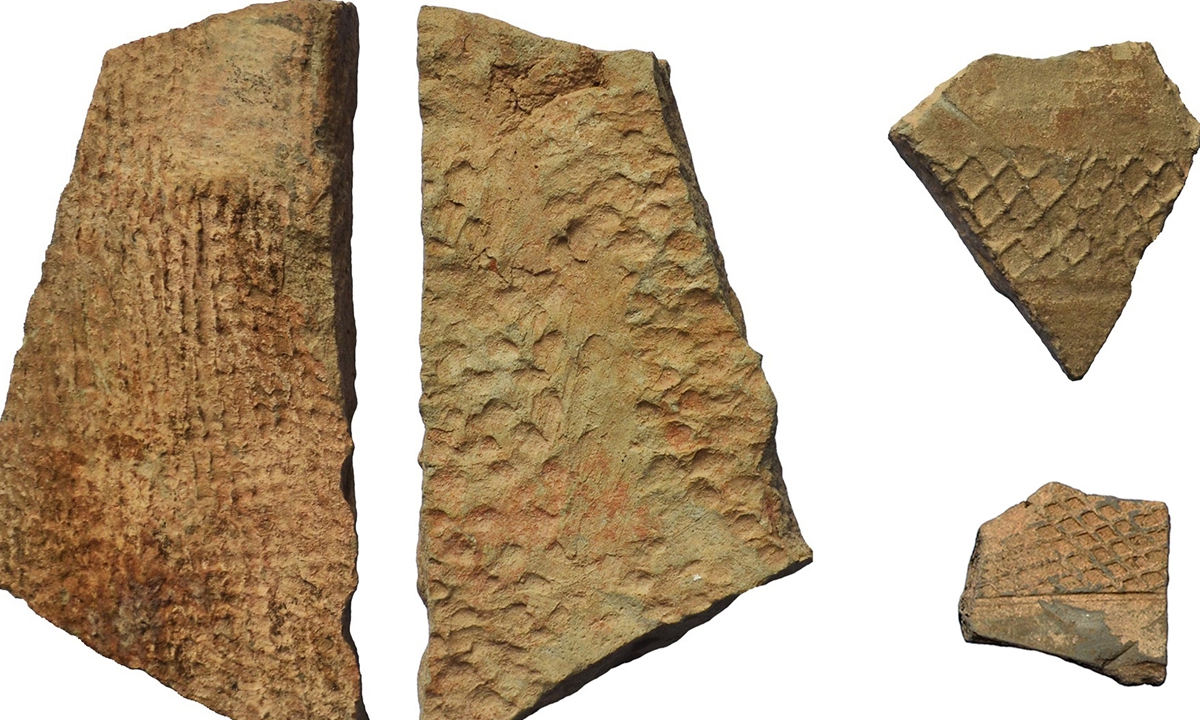
Additionally, this survey identified a small Qin-and-Han period site immediately adjacent to the road, believed to be a courier station or maintenance facility. A small quantity of typical Qin-and-Han era ceramic tiles was found distributed on parts of the road surface, clearly indicating its period.
Lei also explained that researchers began by sorting through previous studies to identify the most well-supported and accurate conclusions regarding the route. Based on this, and in combination with satellite imagery, they located the known distributions of the southern and northern sections of the Straight Road, thereby clarifying its satellite-view features and overall alignment, which generally runs along the straight line between Jiuyuan and Yunyang.
Building on this foundation, they were able to estimate the approximate distribution of the yet-undiscovered section within Yulin. In these areas, researchers selected terrain suitable for observation, first searching and identifying suspected segments via satellite, then conducting field surveys for verification.
This investigation successfully used a combination of satellite imagery analysis and on-site fieldwork to identify this massive relic amidst the loess hills and ridges. The effective experience gained will aid future efforts to locate other as-yet-unknown segments in sandy-covered regions.
RELATED ARTICLES