E. China ups guard against storm, gales as Typhoon Chanthu sweeps across
Transport suspended, schools closed as storm sweeps through

Students in Shanghai leave schools on September 13 as classes are suspended due to Typhoon Chanthu. Photo: VCG
Suspending air and railway transport, halting port operations, canceling school classes… East China's Zhejiang and Fujian provinces and the Shanghai Municipality have moved to minimize the impacts of Typhoon Chanthu, as it swept across China's eastern coast on Monday.
Meteorological experts told the Global Times that the typhoon will not land in the area but the rainfall and gale intensity will remain strong in the following two days, and they urged people and relevant departments in the area to be on guard against geological risks.
Chanthu, the 14th typhoon of 2021, has reached the sea off Hangzhou Bay as of 2 pm on Monday and will circle from the bay to the Yangtze River in the next two days, according to the National Marine Environmental Forecasting Center.
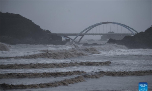
Affected by the typhoon, wild waves reaching six to nine meters were observed in the East China Sea from Monday morning to afternoon, and waves of four to six meters appeared in Zhejiang's near-shore waters.
"Chanthu is considered one of the strongest tropical cyclones this year, and it may bring more severe downpours and gales," chief forecaster Gao Shuanzhu at the National Meteorological Centre said.
Parts of East China's Jiangsu, Anhui and Zhejiang provinces and Shanghai will experience heavy to torrential rains from Monday to Tuesday morning.
In some cases, there may be extreme rain totals of up to 250 to 280 millimeters. Gale-force winds will accompany the downpours in these areas, the NMC said.
Wu Rui, chief service officer at the Shanghai Meteorological Bureau, told the Global Times on Monday that the typhoon is expected to hover over the sea about 100 to 200 kilometers away from Shanghai, and then move away to the northeast on Thursday.
"The wind force is expected to decrease gradually to about 10 kilometers per hour, while the storm moves northward by west, suggesting that the typhoon will still have a significant rain and wind impact from Monday to Wednesday," Wu noted.
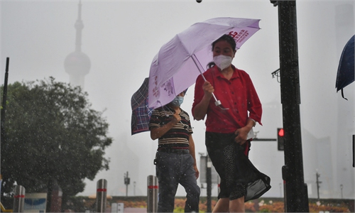
The Global Times found that the most popular scenic spots in Shanghai, including the Lujiazui commercial hub, viewing platform of The Bund, Oriental Pearl Tower, and the aquarium, were all closed, with a few tourists still taking photos outside.
Pedestrians with umbrellas struggled to walk against the gales and rain, some having their umbrellas brutally overturned by the wind and some trying to keep their hats from being blown away.
Supermarkets stayed open, and local residents' work and life went on largely as usual, the Global Times learned on Monday. However, some air passengers were told to reschedule their flights due to suspensions of air traffic.
Liu Hanhua, a chief forecaster of Zhejiang Meteorological Bureau, told the Global Times on Monday that it's highly possible that Typhoon Chanthu "won't land in Zhejiang, as it has changed its direction.
"It was predicted that the subtropical high would strengthen, and there would be high pressure in the north, but those things didn't happen. So its path did not go west, as predicted," she said.
In the coming days, Zhejiang will still face challenges from strong wind and heavy rain, but the downpours are expected to weaken significantly and become less widespread, she said.
Liu noted that the typhoon will mainly move around the east side of the Zhoushan islands, and then it will sweep around the east of the Yangtze River, but its moving speed will be very low. The storm will begin moving to the north on Monday evening, affecting the Hangzhou Bay area, southern Jiangsu, Shanghai and the northeastern part of Zhejiang, she said.
The chief forecaster added that the "emergency warning" will be downgraded to a "warning" soon. The effect of the typhoon on China is predicted to end on Thursday, she added.
Experts cautioned that full preparations should be made, regardless of whether or not the typhoon will land, as some places have already seen heavy rain of more than 300 millimeters in the past 24 hours, which might lead to serious geological risks.
To minimize the impact of the storm, coastal regions including East China's Zhejiang, Fujian and Shanghai have rolled out preventive measures in full swing.
On Monday morning, more than 2,000 inbound and outbound flights were canceled in the four airports in Shanghai, and in Zhejiang's Hangzhou and Ningbo.
Train services in the Yangtze River Delta region were canceled from 12 pm on Monday to 12 am on Wednesday.
Zhejiang upgraded its emergency response to Level I starting at 6:30 pm on Sunday, local authorities said. Coastal passenger transport lines in Zhejiang and water engineering projects have all been suspended, as well as the province's port operations. Zhejiang has sent out alerts about geological disasters and mountain torrents, and traffic controls will be conducted.
Shanghai upgraded its typhoon alert to orange. The city's Pudong district government has set up 320 temporary sites for the safe transfer of residents, and more than 92,000 people had been relocated as of Monday at noon.
Primary and secondary school and kindergarten classes were suspended in Zhejiang and Shanghai for Monday to Tuesday.
East China's Fujian Province halted port operations, with all 3,419 fishing boats anchored inside the port, and more than 20,000 personnel in the province's Putian evacuated.
RELATED ARTICLES