Chinese experts find apparent errors in biased data on Chinese dams on Mekong River by US-funded project
By Published: Mar 02, 2022 09:28 PM

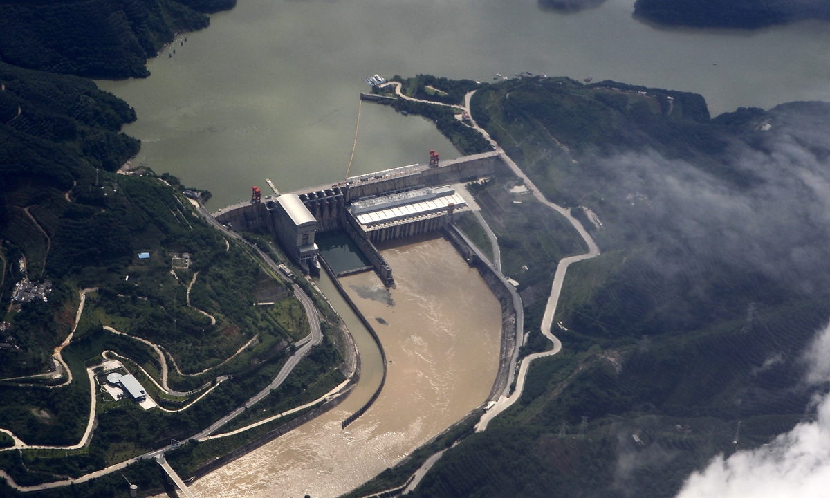
Jinghong hydropower station located in Southwest China's Yunnan Province Photo: IC
Chinese hydrological experts discovered that the reservoir level readings released by the US State Council-funded program "Mekong Dam Monitor (MDM)" were full of serious errors and differed significantly from the actual gauge, which can easily be misused in the hyping of Chinese dams "controlling water" and "hurting downstream countries."
A US-funded project has gone into overdrive to slander China by publishing reservoir level readings and operation curves at all major Chinese dams on the Mekong River as often as on a weekly basis. In the name of "enhancing mutual understanding," the US, a non-regional country, is actually trying to find support for its orchestrated theory of "Chinese dams' threats to downstream countries." But, the evidence was found to be riddled with flaws.
Chinese hydrological research team from Tsinghua University have found that MDM's data could not constantly reflect the overall trends of water availability, which errors observers say were partly caused by backward tools and backdoor political considerations.
The MDM was run by the US-backed institution Stimson Center's Southeast Asia, which has been a US-recruited persistent attacker of Chinese dams in recent years.
Started on December 15, 2020, the program monitored the hydrological and climactic information, and the satellite aerial photographs and analysis of all 13 completed dams, including China's 11 dams, and reservoirs on the Mekong mainstream in addition to 15 tributary dams.
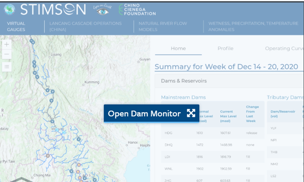
Screenshot of official web page of the Mekong Dam Monitor
Error-ridden reports
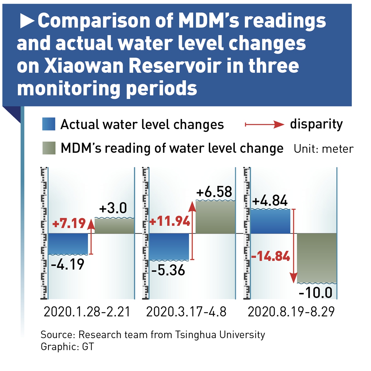
Taking China's Xiaowan Reservoir's level readings as an example, researchers found that the data obtained by MDM's satellite remote measurements reverses the actual water level rise and fall trends at least in three monitoring periods in 2020, with errors ranging from 3 to 10 meters.
MDM's reading at the Jinghong Reservoir, in another instance, presents graver contradictions as it almost entirely does not fit the real condition at any time during the investigated period from January 2019 to July 2021, resulting in error-ridden conclusions. Experts concluded that satellite images and digital elevation models used by the MDM are not well suited for narrowly-shaped reservoirs such as Jinghong.
And as for another major Chinese reservoir, Nuozhadu, on the Lancang River, the MDM's data could reflect the overall trend from 2016 to 2021, but produced large deviation in certain parts.
The Chinese scientists came to these conclusions by comparing MDM's data with actual water level readings provided by dam operators. The Chinese scientific group drew on the laser altimeter satellites to give the same conclusions in their double analyses.
"The laser altimeter satellites we use is one of the most accurate altimetry satellites for measuring water levels worldwide. Therefore, we are confident to point out the shortcomings of the traditional methods used by MDM in drawing such conclusions," the research team from Tsinghua University told the Global Times.
The error is apparently significant when it comes to long and narrowed reservoirs, the Chinese research team found. They revealed that the data and conclusions by MDM for China's reservoirs were barely identical, with faint parallels only being identified at the Xiaowan, Nuozhadu, and Gongguoqiao reservoirs.
Additionally, the Global Times' investigation also found some glaringly wrong figures in an MDM-published dataset. In a Facebook post, for example, MDM said that "There was a significant flow restriction of 144 cubic kilometers at the Jinghong Dam" during the week January 31 and February 6.
But the Global Times found 144 cubic kilometers is ironically far larger than the entire storage capacity of the Jinghong Dam. Moreover, it is more than 1,000 times larger than the entire weekly water release amount by all 45 dams in the basin.
Repeat failures
This isn't the first time that deviations, even contradictions, in MDM results are being exposed.
In 2019-2020, MDM launched a high alert for a "China dam threat," by claiming that the drought in the lower Mekong region was due to China's upstream dams' withholding of water. However, its own results were embarrassingly contradictory.
MDM blamed China's reservoirs for withholding large amounts of water during the wet season (June-December 2019), leading to a drought downstream.
However, it further claimed that the wet season rainfall in Lancang River was larger than previous years, while they revealed two major Chinese reservoirs - Nuozhadu and Xiaowan - withheld significantly less water in the wet season than they had previously.
By its own logic, more rainfall but less storage in China's reservoirs should lead to drought alleviation downstream, not exacerbation. This shows that MDM's conclusions are contradictory and untenable, said the experts.
By contrast, China, which also suffered a severe drought in 2019 and 2020, insisted on releasing 17 billion cubic meters of water downstream to help alleviate the drought downstream, applauded by other riparian countries.
Marc Goichot, freshwater lead for WWF Asia-Pacific, has claimed that China's dams can actually provide a buffer against downstream droughts as they discharge water for power production.
"Many people think dams and climate change are the reasons for less fresh water supply, but it's difficult to say what is causing what at what stage… It's easy to jump to blame those two," says Goichot.
Yet these contributions seem to have been deliberately ignored, amid the US' pattern of stepping in to exacerbate resource issues and sow discord among the members by tarnishing China's efforts in the area, in working with US-based NGOs, lobbyists, and media outlets, observers suggested.
Suspicious motives
Experts have pointed out that MDM's bull's-eye is clearly on China, as they occasionally hold online forums to discuss and agitate allegations of adverse downstream effects of upstream dams, turning a blind eye to their alleviation effects.
It ignored the fact that the flow in China's basin only accounts for 13.5 percent of the total runoff of the Mekong River, with very limited impact on the lower reaches of the river.
Two key figures of the MDM program's host Washington-based Stimson Center, Alan Basist, who has experience working in the US government, and Brian Eyler, have all been persistent critics of alleged Mekong River issues in recent years and repeatedly lambasted China in media interviews. They smeared China for "sophisticatedly orchestrating and operating its mainstream dams" along with other unfounded accusations.
The MDM is supported by the Mekong-US Partnership, experts pointed out. The US has ramped up its efforts in strengthening US participation in Indo-Pacific affairs, which are strategically significant to its national interests, through multilateral mechanisms such as Quad, the Mekong-US Partnership, and APEC, analyzed Ge Hongliang, deputy director of the College of ASEAN Studies at Guangxi University for Nationalities.
The Chinese government has publicly called on countries outside the region to stop interfering and stirring up water-related issues in the Mekong region.
China and other Mekong countries have, in recent years, overcome external "noise and interference" to push forward with cooperation on water resources, said China Foreign Ministry spokesman Wang Wenbin at a press meeting in December 2020.
China welcomes constructive advice on water resources but opposes "malicious provocation," said Wang.
With a $150-million initial investment, the US activated a Mekong-US partnership in September 2020, as an integral part of its "Indo-Pacific vision," which observers believe shows its accelerated pace in politicizing the water resource issue in the region to curb China's growing influence in Southeast Asia.
The US launched a fierce narrative battle against China around the region in 2020. Working with US-backed NGOs, think tanks, lobbyists, and media, the US hyped environmental and resources issues and sowed discord among the members by tarnishing China's efforts in the region.
"Many of the self-proclaimed US researchers did not even conduct field work in the Mekong basin before drawing their 'conclusions,'" Bi Shihong, a professor on China's Neighbor Diplomacy Studies at Yunnan University, told the Global Times previously. "The reports of those institutions are less scientifically valuable, and member countries usually review the conclusions independently with more caution."
Experts recommended that riparian countries strengthen relevant research on the joint operation of reservoirs both upstream and downstream, as well as in the mainstream and tributaries, so as to make good use of these reservoirs and provide technical support for the benefits of the whole basin.
To contribute to these collaborative efforts, China has made good on its promise to share year-round hydrological data from the upper reaches of the Mekong River since November 1, 2020.
It is normal that upstream and downstream countries have different, even conflicting, interests in the development and utilization of cross-border water resources. However, there is no serious water conflict in the Lancang-Mekong River, contrary to the views of some Western media reports and scholars, Zhai Kun, an expert on the Mekong region with the School of International Studies at Peking University, told the Global Times in a previous interview.
RELATED ARTICLES