Exclusive: Satellite images show Gaza in complete darkness after power supply cutoff, indicating worsening humanitarian crisis
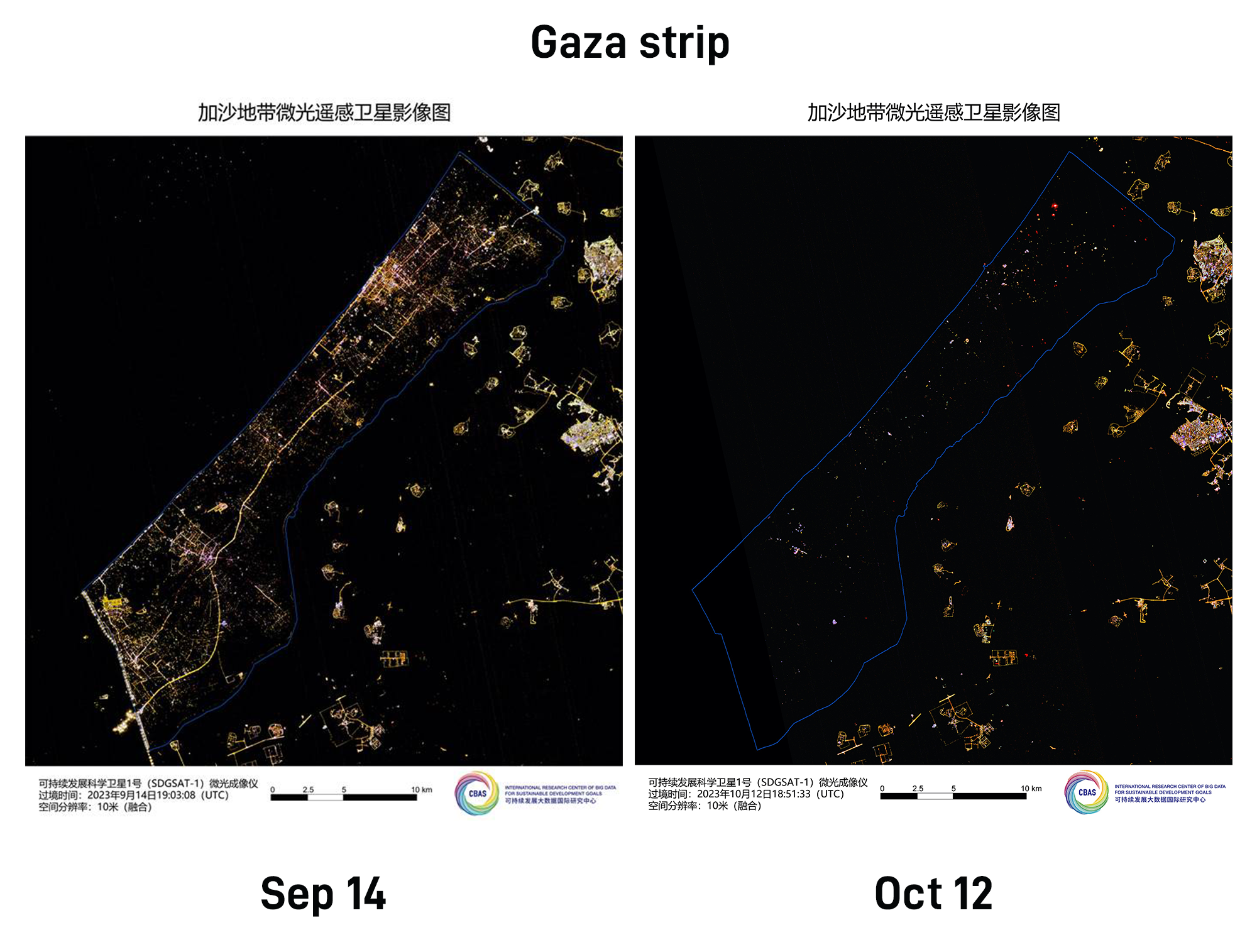
Satellite images of Gaza Strip on September 14, 2023 and October 12. Photos: Courtesy of SDG Center
According to the latest satellite images obtained by Global Times reporters from the International Research Center of Big Data for Sustainable Development Goals (SDG Center) on Saturday, the Gaza Strip, one of the most densely populated areas in the world, is almost completely plunged into darkness at night due to Israel's power supply cut-off. This stark contrast to the previously well-lit nights in the region highlighted the difficult living conditions faced by the people in the Gaza Strip. Since the Israeli military announced the cutoff of water and power supply to the Gaza Strip and implemented a comprehensive blockade on Monday, a humanitarian crisis in the Palestinian Gaza Strip has worsened.
The Gaza Strip is a narrow strip of land measuring 41 kilometers long and 6 to 12 kilometers wide, per official information by Palestine. More than 2 million people, the majority of whom are Palestinians, live on a total land area of approximately 365 square kilometers, making it one of the most densely populated areas in the world, with population density comparable to that of Madrid in Spain, and London in the UK.
The night view image of the Gaza Strip, taken around 10 pm local time on September 14, using the low-light imaging instrument of the SDG Center's satellite, shows that before the recent Palestine-Israel conflict, the entire Gaza Strip was brightly lit at night, which visually reflected the high population density in the region.
Two-thirds of the electricity supply in the Gaza Strip comes from Israel. On Wednesday, the only power plant in Gaza had to shut down due to fuel shortages after Israel announced a complete blockade on the region. As a result, the entire area experienced a complete blackout, leading to an escalating humanitarian crisis.
The Palestinian Ministry of Health warned Wednesday that all hospitals in Gaza would soon run out of fuel for electricity, resulting in "disastrous consequences." On Thursday, the International Committee of the Red Cross issued a warning that hospitals in Gaza were turning into "graveyards" due to the lack of power supply. The power outage also affected the operation of local communication systems and the preservation of daily food for residents, who were also unable to withdraw their savings from banks. UN Secretary-General António Guterres also pointed out on Friday that the power outage in Gaza has triggered a drinking water crisis.
The latest satellite images obtained around 10 pm local time on Thursday also showed that after a complete power outage, the Gaza Strip is almost plunged into complete darkness at night, with only sporadic lights. This also means that the entire Gaza Strip has been paralyzed, and the basic livelihood of local residents cannot be guaranteed.
Satellites with low-light imaging payloads have the ability to reflect the socioeconomic development and living standards of a region by detecting the intensity and distribution of nighttime lights. Currently, the majority of satellites with low-light imaging capabilities are operated by China, the US, and Israel. The low-light imaging satellites of the US and Israel are mainly used in military, environmental monitoring, and mapping fields.
China's Sustainable Development Scientific Satellite-1 is the world's first scientific satellite specifically designed to serve the United Nations' 2030 Agenda for Sustainable Development. This satellite was developed under the guidance of the Chinese Academy of Sciences' "Earth Big Data Science Engineering" pilot project and is the first launch planned by the SDG Center, a global research institution dedicated to serving the UN agenda through big data.
After its operation in orbit, the data of this satellite is shared globally, providing support for research on sustainable development goals, especially for developing countries. It contributes to and sets an example of reducing the global imbalance in sustainable development and the digital divide between regions.
RELATED ARTICLES