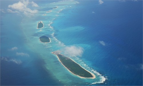
Picture shows the scenery of China's Nansha Islands in the South China Sea Photo: VCG
China released the findings of its mammoth geological exploration of the South China Sea on Tuesday, marking a significant milestone in compiling a basic marine geological survey of the South China Sea and its adjacent seas.
The exploration was conducted over 25 years by the Guangzhou Marine Geological Survey (GMGS), under the direct control of the China Geological Survey under China's Ministry of Natural Resources. It completes the geological survey covering waters under China's jurisdiction in the South China Sea to achieve comprehensive coverage of the basic geology of the area.
The exploration achievements were officially published in a series of books on the geology of the South China Sea and its adjacent seas.
With a complex geological structure and abundant mineral resources, the South China Sea serves as a crucial experimental field and resource continuation zone for earth science research.
Over the past 25 years, the GMGS has acquired a considerable amount of valuable firsthand survey data of marine geology and physical geography which have filled the blanks in research of deep-sea areas of the South China Sea. GMGS also identified essential geological elements, compiled foundational digital geological maps and established a systematic set of results based on the data.
These achievements have laid a solid foundation for making breakthroughs in critical earth science research in the South China Sea and the establishment of an international model for the research on marginal seas.
Based on the measured data, the researchers have been able to comprehensively map the topography of the South China Sea and its adjacent seas, the geology, stratum and depositional system of the Late Quaternary and the Meso-Cenozoic geological structural evolution, the types and distribution of mineral resources, and the marine environment and geological hazards in the South China Sea and its adjacent areas.
These research findings provide important geological theoretical support for the exploration and development of mineral resources in the South China Sea, including petroleum, natural gas, gas hydrates (combustible ice) and heavy metal placer deposits.
Through systematically analyzing a large amount of measured topographic data, 36 new submarine geomorphic units and 47 categories of landform types have been identified in the South China Sea. Additionally, 384 geographic entities on the sea bottom in the South China Sea have been systematically named, with approval from relevant authorities for their public release, which plays a crucial role in areas such as the management of China's marine natural resources.
Meanwhile, researchers have systematically summarized the distribution patterns and mechanisms of environmental geological hazards in the South China Sea, believing that there is a high risk of geological hazards in the shelf slope-break of the South China Sea, where submarine landslides and shallow seafloor gas seepage are prone to occur.
Global Times
RELATED ARTICLES