Typhoon Matmo makes 2nd landfall in S.China's Guangxi, bringing heavy rainfall and strong winds
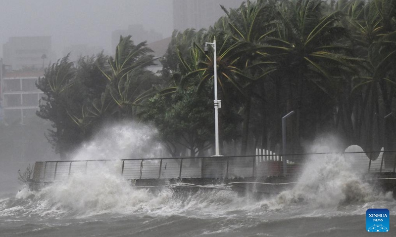
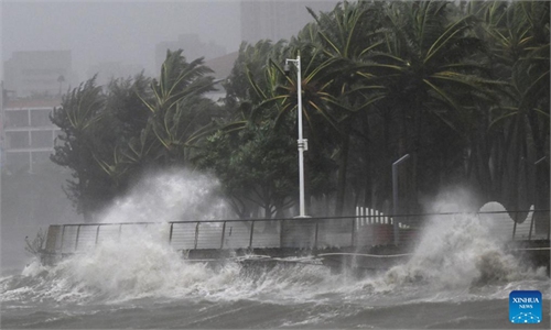
This photo taken on Oct. 5, 2025 shows high waves in a seashore area of Haikou, south China's Hainan Province. Photo: Xinhua
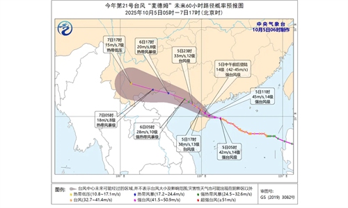
Typhoon Matmo, the 21st typhoon of the year, made its second landfall along the coast of Fangchenggang in South China's Guangxi Zhuang Autonomous Region at around 1:10 am Monday, according to the China Meteorological Administration (CMA).
At landfall, the storm's maximum sustained winds near the center reached force 10 of strong tropical storm level at 28 meters per second, with a minimum central pressure of 982 hPa, according to the CMA.
The storm is moving northwestward at a speed of 15 to 20 kilometers per hour and is expected to gradually weaken, while continuing to bring heavy rainfall and strong winds along the coast, the administration said. The National Meteorological Center issued a blue warning for typhoons at 6:00 am on Monday.
From 8 am Monday to 8 am Tuesday, winds of force 6-7 scale and gusts of 8-9 scale are expected over the northwestern and northern parts of the South China Sea, the Beibu Gulf, southern Guangxi and its coastal areas, southwestern coastal Guangdong, and coastal Hainan. In parts of the northern Beibu Gulf and southern Guangxi, wind speeds may reach 8-9 scale with gusts up to 10-11 scale, the CMA said.
Heavy rainfall is also forecast for parts of central and western Guangxi, southwestern Guizhou, southeastern Yunnan, and western Hainan, with some areas in western Guangxi and southeastern Yunnan likely to experience torrential rain totaling 100-190 millimeters.
Over the next three days, Matmo is expected to continue bringing heavy rainfall to Guangxi and Yunnan, along with strong winds along the Guangxi coast and in the Beibu Gulf, per the CMA, warning of potential secondary disasters.
Frequent rain is also expected in the Sichuan Basin, eastern parts of Northwest China, Inner Mongolia, and North China, while cold air activity may bring rain and snow to the Qinghai-Tibet Plateau and Xinjiang, potentially affecting travel, agriculture, and tourism.
The Hong Kong Observatory canceled all tropical cyclone warning signals at 10:20 pm on Sunday, as Matmo moved away and gradually weakened, local media reports said. However, occasional strong winds may still affect offshore and highland areas, and rough seas will persist. The public has been advised to stay away from the shore and avoid water activities.
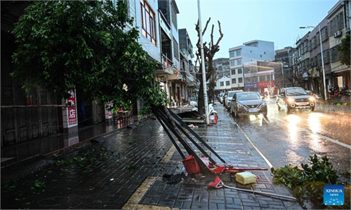
Matmo first made landfall on the eastern coast of Xuwen county, South China's Guangdong Province, on Sunday. footage showed the typhoon battering Haikou and Wenchang in Hainan Province, while iron sheets were being blown away and snapping trees.
As of 8 pm on Saturday, a total of 151,352 people had been relocated in Guangdong Province, including 9,916 by sea and 141,436 by land, CCTV News reported.
Global Times
RELATED ARTICLES