Beijing’s first snowfall of 2026 continues as nationwide cold wave possibly brings widespread snow and ice
Beijing residents witness the first snow of 2026 on January 18, 2026.Photo: VCG
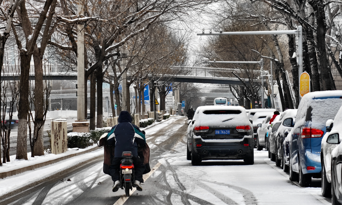
Beijing’s plain areas continue to see light snow on Sunday morning, with yellow alerts in place for icy roads and prolonged low temperatures, according to the Beijing Meteorological Service. The snowfall came a day after many districts in the capital welcomed their first snow of 2026 on Saturday night. The weather authority also urged the public to stay warm, guard against freezing conditions and pay attention to travel safety, noting that northerly winds would strengthen after the snow.
Meteorological data showed that from 6 am on Saturday to 7 am on Sunday, the city recorded an average snowfall of 1.2 millimeters, with urban areas averaging 1.6 millimeters. The heaviest snowfall was reported at the Qianlingshan in Beijing’s Fengtai district, at 9.9 millimeters. In the most recent hour of monitoring between 6 am to 7 am, the highest hourly snowfall, 0.4 millimeters, was recorded at the Beijing Jiaoke Experimental School in Fengtai district.
Light snow was expected to continue across most parts of the city from Sunday morning through midday, with more noticeable snowfall in some western and southern areas, per meteorological service.
After snowflakes were spotted drifting down over Beijing on Saturday evening, landmarks including the Palace Museum, Jingshan Park and traditional hutong neighborhoods quickly became popular destinations for residents and tourists to photograph snowy scenes. The snowfall drew widespread attention on social media, with the hashtag asking why this round of snow featured such large flakes climbing to the top of trending lists on Chinese social media platform Weibo.
According to the Beijing Daily, meteorological experts explained that the snowfall was caused by an easterly wind “backflow” weather pattern. Under this pattern, Beijing experienced snow in the morning and again in the evening on Saturday, with more obvious snowfall along mountainous areas. This type of backflow snowfall is typical in North China and relies on easterly winds. The terrain of Beijing’s western mountains blocks the easterly airflow and moisture at the mountain front and foothills, enhancing low-level uplift and making heavier snowfall more likely in western and mountain-adjacent areas.
During this process, cold easterly air traveled from the Bohai Bay toward Beijing, bringing abundant moisture. As the air was forced to rise over western terrain, snowfall clouds formed, with cloud temperatures ranging from minus 10 to minus 20 C, conditions favorable for rapid snowflake growth. As snowflakes fell, they collided and stuck together, forming large, fluffy flakes or snow clusters, creating the visual effect often described as “goose-feather snow.” Because of their loose structure, such snow can also make accumulated snow appear deeper, per Beijing Daily.
Following the snowfall, multiple local government departments issued public appeals calling on institutions and residents to participate in snow and ice removal. Party and governments, as well as enterprises and public institutions, were encouraged to take responsibility for designated sections of roads, according to local environmental authorities.
As of Sunday morning, snowfall had already led to operational adjustments on 18 bus routes in Beijing. The Capital Airport also activated a Level I coordinated operation response mechanism to ensure transport safety, according to the Beijing Daily.
Beijing is not alone in facing wintry conditions. According to China’s Ministry of Emergency Management, the year’s first large-scale cold wave began affecting China on Saturday. From January 17 to 21, the cold wave is expected to sweep from north to south across most of the country, bringing sharp temperature drops, strong winds, rain, snow and freezing conditions.
Many regions are likely to record their lowest temperatures of the winter so far, with southern areas such as the Jianghan and Jiangnan regions facing especially steep temperature declines due to previously mild conditions. Central and eastern China are forecast to experience widespread snow, freezing rain and icy weather over the coming days.
The National Meteorological Center renewed a blue alert for the cold wave at 10 am on Saturday, with average or minimum temperatures across much of China expected to fall by 6 to 12 C from January 17 to 21 under the influence, accompanied by strong winds. By the morning of January 21, the 0-degree Celsius line is forecast to shift southward to areas including southern Guizhou, southern Hunan, central Jiangxi and southern Zhejiang.
Meanwhile, central and eastern China are set to undergo the largest, strongest and most extensive rain, snow and freezing event since the start of winter. From Saturday to Sunday, eastern North China and the Huanghuai region are expected to see light to moderate snow or sleet. Monday is forecast to be the peak period of the process, with complex transitions between rain, snow and freezing rain south of the Qinling Mountains–Huaihe River line.
To cope with the evolving weather conditions, national authorities on Saturday dispatched multiple departments to provinces including Shanxi, Anhui, and Guizhou to assess the risks posed by low temperatures, snow and ice and to deploy preventive measures.
Global Times
RELATED ARTICLES