IN-DEPTH / IN-DEPTH
Chinese, intl scientists reveal key link in Asian Water Towers' atmospheric water cycle, helping advance regional climate projections amid global warming
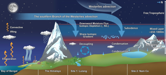
Schematic illustration of the two decoupled conveyor mechanisms driving the vertical integration of moisture advected by the westerlies into the atmospheric water cycle on the AWTs. Photo: Courtesy of the Institute of Tibetan Plateau Research, Chinese Academy of Sciences
Chinese researchers, in collaboration with international scientists, have identified a "vertical conveyor" atmospheric mechanism that powers the atmospheric water cycle in the Qinghai-Xizang Plateau, known as the Asian Water Towers (AWTs). This finding, supported by the Second Tibetan Plateau Scientific Expedition and Research (STEP), reveals how moisture from high-altitude winds is delivered to the plateau through a complex process of nocturnal "decoupling," the Global Times learned from the Institute of Tibetan Plateau Research (ITP), Chinese Academy of Sciences, on Tuesday.
These findings provide key constraints for atmospheric models, climate projections, and interpretations of regional isotope proxy records, according to a paper on the study recently published online in Proceedings of the National Academy of Sciences (PNAS).
The AWTs, a high-altitude region with a mean elevation exceeding 4,000 meters, serve as the primary freshwater source for nearly 2 billion people. While the Indian Summer Monsoon is a well-known controller of seasonal rain, a key knowledge gap remains: how the mid-latitude Westerlies, which dominate the region for three-quarters of the year, integrate their moisture into the local water cycle under non-precipitating conditions, according to materials provided to the Global Times by the ITP.
Recent cryospheric imbalances across the AWTs, threatening water security for over 2 billion people, reflect the coupled effects of large-scale atmospheric circulation and global warming. However, disentangling these effects remains challenging due to the knowledge gap, according to a PNAS paper.
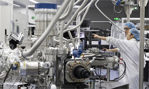
To solve this problem, a research team led by Professor Gao Jing and Yao Tandong from the ITP combined in-situ vertical observations with the state-of-the-art ECHAM6-wiso isotope-enabled atmospheric model, providing the first unified, process-based picture of how atmospheric water in the AWTs is supplied.
Using specialized helium-tethered "Jimu Balloons," the team captured 32 unprecedented vertical profiles of atmospheric water vapor stable isotopes and meteorological parameters at Lulang, a forested moisture corridor, and Nam Co, a high-altitude inland lake. These isotopes allowed the team to identify a highly stratified atmospheric structure: the Atmospheric Boundary Layer, located at roughly 600-900 meters, where locally sourced moisture is shaped by diurnal cycles; the Mixed Layer, an intermediate zone between 600 and 1,600 meters characterized by minimal isotopic variance; Free Troposphere, found above 1,600-1,800 meters, where large-scale Westerlies transport moisture across the Himalayan barrier, according to the ITP.
The study reveals that the remote-source atmospheric water vapor undergoes subsidence driven by the Westerlies, causing large-scale advection to descend toward the AWTs' atmospheric boundary layer. As this moisture sinks, it interacts with local air, creating two distinct thermal inversion layers. These layers act as physical "caps" that suppress vertical mixing and decouple atmospheric water vapor into distinct layers. This decoupling isolates the cold, dry Westerlies moisture aloft from the relatively moist, local air trapped within the atmospheric boundary layer. This process constitutes a primary pathway for integrating Westerlies-advected moisture into the local moisture budget without precipitation, sustaining near-surface moisture accumulation. Even without precipitation, approximately 30 percent of the moisture flux transported by the Westerlies is integrated into the local water cycle through phase transitions at night, according to the ITP.
As anthropogenic warming drives rapid hydrological transitions, including accelerated glacier retreat and altered runoff patterns, the findings of this study provide critical benchmarks for improving atmospheric models, optimizing climate projections of the accelerating water cycle in the AWTs, and advancing the climatic interpretation of regional isotopic records, such as those from ice cores, according to materials the ITP provided to the Global Times.
RELATED ARTICLES