IN-DEPTH / IN-DEPTH
Climate Gambit: Chinese research team reveals exclusively to GT how a swarm of drones can give a typhoon three-dimensional CT scan
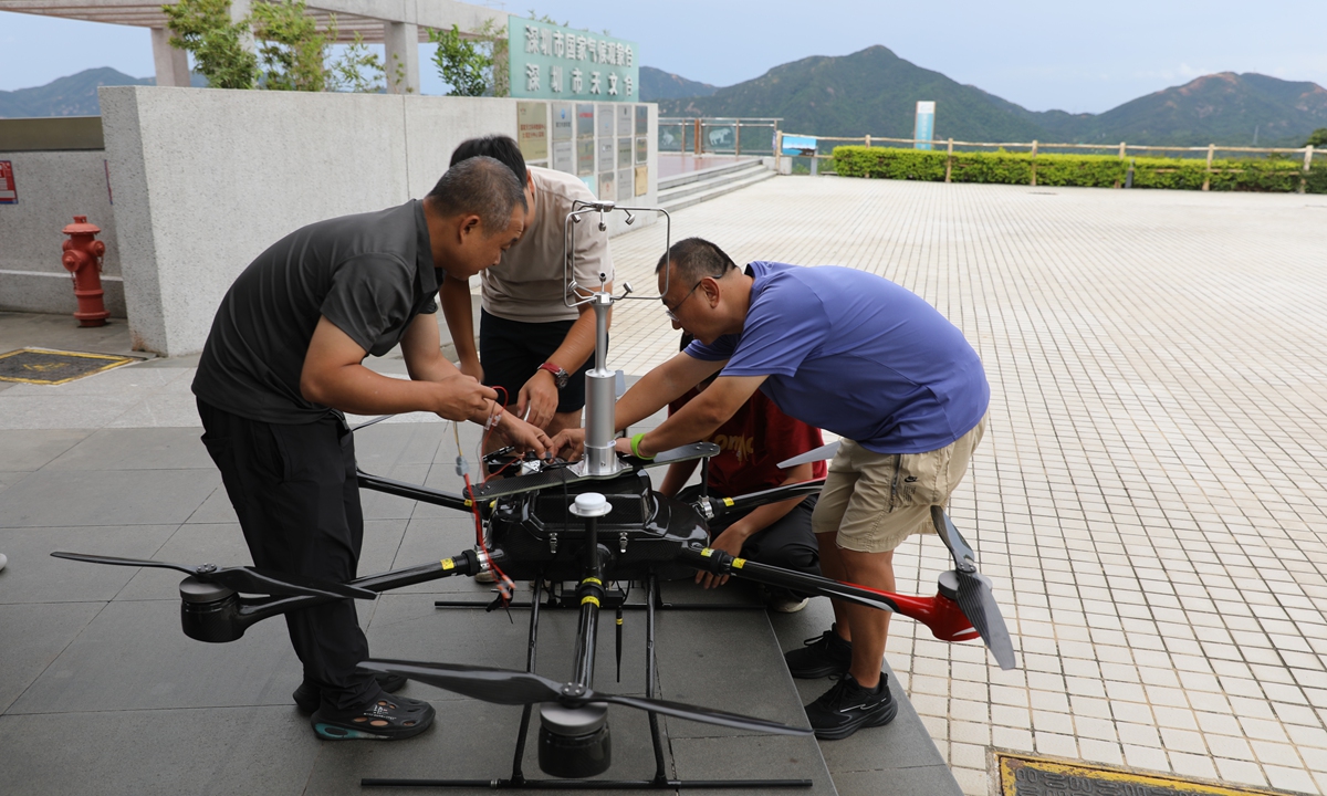
Guo Jianping's team adjusts and tests the drones before the field experiment on July 25, 2026. Photo: Courtesy of Guo Jianping
Editor's Note:Extreme weather is increasingly a global challenge, and the key to addressing climate risks lies in earlier prediction, more precise action, and smarter preparedness, with emerging technologies playing a vital role. The Global Times launches the "Climate Gambit" series, exploring how research teams are leveraging cutting-edge technologies, including artificial intelligence, high-performance computing, and smart observation systems, to anticipate weather changes, enhance disaster early-warning, and strengthen resilience against climate risks.
Why would anyone willingly fly a swarm of drones straight into a howling typhoon? And what could such a risky maneuver reveal that satellites and weather radars cannot?
As Typhoon Noul bore down on China's southern coast this past July, a team of Chinese meteorological experts did exactly that - and for the country's first time, they used a coordinated swarm of unmanned aerial vehicles to observe the storm's full life cycle, from landfall to dissipation, at high frequency and across multiple dimensions.
In an exclusive interview with the Global Times, Guo Jianping, a professor at the Chinese Academy of Meteorological Sciences and the leader of the experiment, revealed the technological challenges involved, how the drone swarm helped researchers observe the storm's interior, and how the technology could support weather forecasting and disaster prevention and mitigation in the future.
'Straight into the storm's interior'
At dusk on July 25, with Typhoon Noul closing in on the coast of South China's Guangdong Province, the operation unfolded at the China Meteorological Administration's (CMA) field experiment base for low-altitude economy and unmanned aviation weather support, perched on Shenzhen's Dapeng Peninsula.
By 6:50 pm, just before the typhoon made landfall - surface winds at the site had reached 17 meters per second.
It was the most hostile, highest-risk stage of the entire operation. "Our team monitored every drone's flight status, formation integrity and data transmission in real time," Guo told the Global Times. That tense half-hour, he said, left the deepest impression on him.
The experiment marks a bold shift in typhoon observation. For decades, China's typhoon monitoring tools - weather satellites, ground radars, manned research aircraft and ocean buoys - could only track storms from the outside. Satellites capture cloud systems from high altitudes, radars detect precipitation echoes, planes traverse spiral cloud bands and buoys record sea surface changes. Yet the critical, highly active low-altitude atmospheric boundary layer beneath offshore typhoon clouds has long lacked continuous, fine-grained direct observations.
The new drone swarm technology fills this gap by forming a mobile, adaptive aerial meteorological network that flies directly into typhoons' low-altitude zones. "China's homegrown Fengyun meteorological satellites and weather radar only let us see the 'roof' of a typhoon," Guo said. "Our drone swarms, equipped with high-precision meteorological sensors, act as a coordinated observation array that flies straight into the storm's interior."
Guo pointed out that the drones are capable ofmulti-point synchronized detection at preset altitudes and locations, the drones deliver on-site, real-time meteorological measurements. This trial also represents China's first full-process three-dimensional observation of low-altitude storm environments throughout a typhoon's transit.
"The drone swarm captures core low-altitude typhoon data - temperature, humidity, wind speed and turbulence - while recording drone flight attitude and energy consumption in real time, accumulating data for wider deployment. Effectively, it performs a dynamic, comprehensive CT scan of the lower atmosphere beneath typhoon clouds," Guo said. Unlike fixed weather stations, the drone system offers unmatched mobility, allowing rapid deployment to key areas and flexiblethe flexible tracking of evolving severe weather systems, he said.
Resilient in violent wind and rain
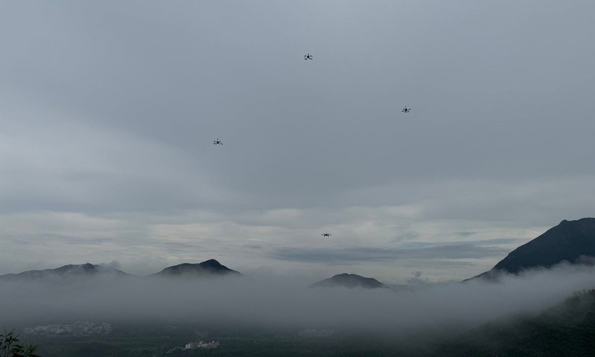
A drone swarm conducts on-site atmospheric observations after Typhoon Noul passed through the area on July 25, 2026. Photo: Courtesy of Guo Jianping
When people hear "drone swarm," they often think of light shows - hundreds of aircraft tracing programmed patterns across a clear night sky. But a low-altitude swarm operating inside a fast-evolving storm faces a very different challenge: it must constantly adjust flight parameters to stay stable in fierce winds and violent turbulence.Guo said the drones used in this experiment had a tested maximum wind resistance of 20 m/s. To achieve that, the team made extensive hardware modifications. "We adapted the entire airframe for extreme environments - reinforcing resistance to wind, rain and vibration, and improving waterproofing," he explained. "We upgraded the power and endurance systems to handle high winds and strong turbulence. And instead of off-the-shelf payloads, we installed dedicated high-precision meteorological modules capable of capturing microscale changes in temperature, humidity and pressure, while keeping weight low and stability high - integrating operations and detection in one package."
Moreover, the drones did not follow predefined routes. Equipped with real-time windfield sensors, they adjusted their speed and altitude on the fly based on in-situ readings. Within the swarm, information was shared instantly: if one drone encountered a strong gust, the entire formation adjusted its pattern simultaneously to avoid collisions or breakup. "Even under extreme conditions, the swarm operated steadily just before landfall," Guo said.
A future beyond typhoons
Drone-based typhoon observation is not new internationally. Fixed-wing and multirotor UAVs have been used for marine boundary-layer studies before, but mostly as single aircraft.
According to Guo, China has long explored drone-based meteorological monitoring. Since 2018, the CMA has carried out exploratory meteorological observation experiments involving mainly large unmanned aircraft under the Haiyan, or Petrel, Project. From 2020 to 2022, the project conducted high-spatiotemporal-resolution vertical observations of oceanic typhoons and the atmospheric and cryospheric environments of the Qinghai-Xizang Plateau, improving forecast skill in typhoon-affected areas by 3 percent. The latest experiment, featuring a heterogeneous swarm of multiple drone types, synchronized networking at fixed points and different levels, and coverage throughout the period before and after landfall, marked the first three-dimensional observation of its kind.
"The value of a drone swarm does not lie in flying higher or farther than others," Guo said. "Rather, it lies in providing a low-cost, replicable and potentially routine observation solution for near-sea, low-altitude areas. This is particularly relevant to countries and regions with long coastlines that are frequently affected by typhoons."
Still, he acknowledged that widespread operational use is not imminent. Observing typhoons with swarms demands extremely high hardware precision, sophisticated coordination algorithms, robust environmental adaptability and strong support infrastructure - not to mention significant R&D and maintenance costs, plus dedicated test bases and specialized teams.
Even so, the technology boasts expansive application potential. Beyond severe weather monitoring, it could significantly improve high-resolution urban weather forecasting. The versatile system is also applicable to marine disaster early warning, offshore wind farm resource assessment, meteorological support for marine ranching and other fields.
"With technological iteration, falling costs and improved industrial standards, small-scale drone swarm observation systems can achieve large-scale commercial use," Guo said. The technology will eventually support the development of a comprehensive low-altitude meteorological support system to support refined weather services across multiple industries.
RELATED ARTICLES