China aerial remote sensing system officially put into operation with 80% of its equipment developed in China
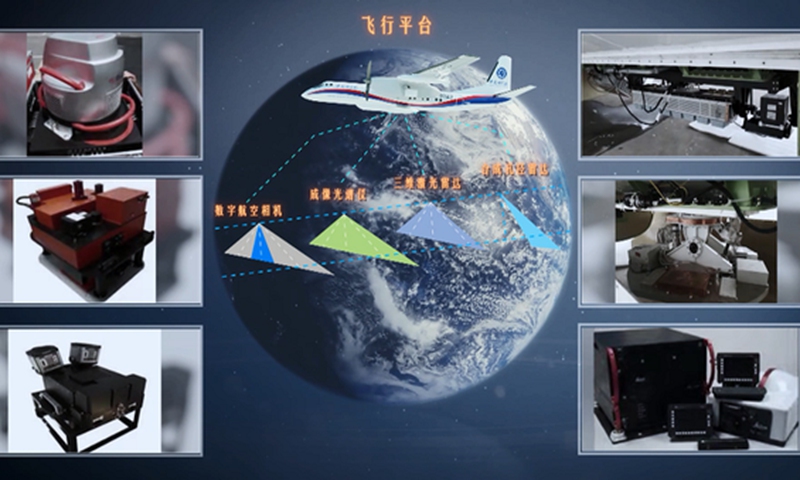
Photo: CCTV News
The China aerial remote sensing system started official operations on Thursday.
The aerial remote sensing platform has most comprehensive capability of its kind in the country, with 80 percent of the equipment independently developed in China, according to the Aerospace Information Research Institute of the Chinese Academy of Sciences (AirCAS).
The system can obtain multiple types of remote sensing data, including land, oceanic and atmospheric records, and provide multiple types of aviation remote sensing services such as scientific experiment mode, cruise mode and emergency response mode among others. The services provided are used in the fields of agriculture, forestry, fishing, surveying and mapping, environment conservation and disaster prevention, according to the AirCAS.
The completion of the aerial remote sensing system has filled the gap in the development of medium-sized aerial remote sensing flight platforms with long range, multi-function and multi-observation windows in China. It also provides key technical means for China's earth science research, AirCAS said.
The China aerial remote sensing system is a major national science and technology infrastructure project approved by the National Development and Reform Commission.
The construction of two domestic medium remote sensing aircraft platforms and more than 10 remote load sensors that are integrated with an aviation remote sensing data processing and management system that can process multi-source information data, are part of the project. It also includes an aviation remote sensing system complex building in Beijing and an aircraft hangar at Yingkou Airport, in Northeast China's Liaoning Province.
RELATED ARTICLES