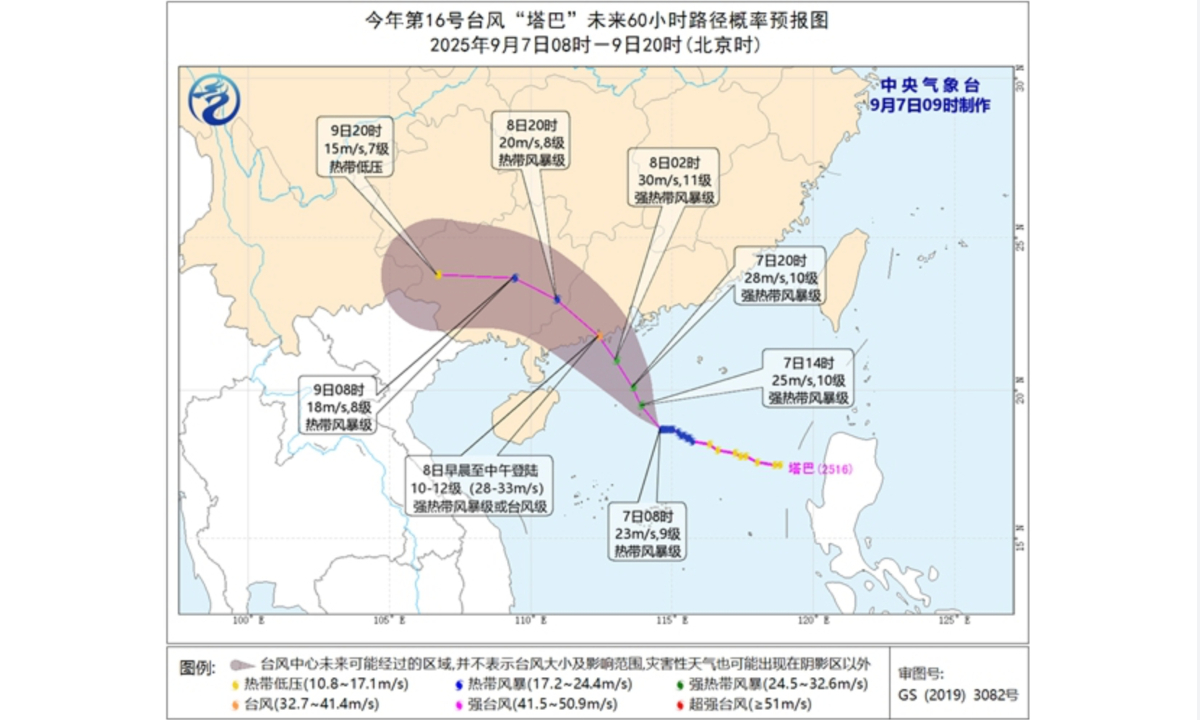
Path probability forecast map of Typhoon Tapah for the next 60 hours. Photo: weather.com.cn
A tropical depression in the South China Sea, edging closer to the coast of southern part of China, strengthened into this year's 16th typhoon, Tapah, on Saturday and is expected to make landfall in South China's Guangdong Province on Monday morning, bringing heavy rains to parts of the coastal areas of Guangdong and Guangxi Zhuang Autonomous Region, China Central Television (CCTV) reported on Sunday.
As Tapah approaches, strong winds and heavy rains will sweep across much of South China, with central and southern Guangdong, central and southern Guangxi, and southern Yunnan expected to see heavy to torrential rainfall. Meanwhile, rain will also persist along the Yangtze River, with Chongqing Municipality, Hubei and Anhui provinces expecting localized heavy to torrential rain.
Between 8 am on Sunday and 8 am on Monday, torrential rain of 100 to 120 millimeters is forecast for parts of southeastern Guangdong and nearby regions, with the maximum hourly rainfall of 20 to 50 millimeters, and some parts exceeding 70 millimeters, according to CCTV.
From Sunday to Wednesday, accumulated rainfall across much of southern China including Yunnan, Guangdong, Hainan and Guangxi could reach 80 to 180 millimeters, with some parts reaching 250 to 400 millimeters, chinanews.com reported on Sunday.
Due to the impact of Typhoon, some railway lines in Guangdong adjusted operations or suspended operation on Sunday, while passenger ferry services in the Qiongzhou Strait were completely suspended starting 2 pm on Sunday, chinanews.com reported
As of Sunday afternoon, Guangdong activated the Level III emergency response for wind prevention, flood and typhoon control in water resources and wind and hydrological monitoring and forecasting.
The Department of Emergency Management of Guangdong Province ordered the suspension of all outdoor group activities and high-altitude outdoor operations. Beaches, scenic areas, parks, and amusement parks were ordered to close, with personnel evacuated.
On Sunday afternoon, the Zhuhai Meteorological Observatory upgraded the city's typhoon warning to a yellow alert which is expected to remain in effect until Monday. All kindergartens, nurseries, and primary and secondary schools across Zhuhai suspended classes, with students advised to stay home or seek nearby shelter from the storm.
At 5 am on Sunday, the typhoon was centered over the northern part of the South China Sea, about 495 kilometers southeast of Dianbai district in Maoming, Guangdong, with the maximum wind near the center reaching 23 meters per second.
Tapah is forecast to move northwest at a speed of 10 to 15 kilometers per hour, gradually intensifying, and is expected to make landfall along the coastal area between Zhuhai and Zhanjiang in Guangdong between the early morning and midday on Monday as a severe tropical storm or typhoon. Its intensity is expected to weaken after landfall.
On Saturday evening, the State Flood Control and Drought Relief Headquarters initiated a Level IV emergency response for flood and typhoon control in Guangdong and Hainan, and dispatched a work team to Guangdong to assist with local relief efforts, according to chinanews.com.
The National Meteorological Center warned of potential disasters such as flash floods, geological hazards, flooding of small and medium-sized rivers, urban waterlogging, and wind damage in the affected areas over the next three days, chinanews.com reported.
Shenzhen, expected to be affected by Tapah, upgraded its citywide typhoon alert from a white alert to a blue alert at 9 am on Sunday as winds strengthened, according to Shenzhen Fabu, the city's official government WeChat account.
Measures include reinforcing roadside trees, construction sites, and glass curtain walls against strong winds, reinforcing seawalls and coastal highways against storm surges, and guarding against flooding, ground subsidence and landslides caused by sustained heavy rainfall, according to Shenzhen Fabu.
Global Times
RELATED ARTICLES