IN-DEPTH / IN-DEPTH
New Year on the Frontlines: Three images of post-90s satellite designer
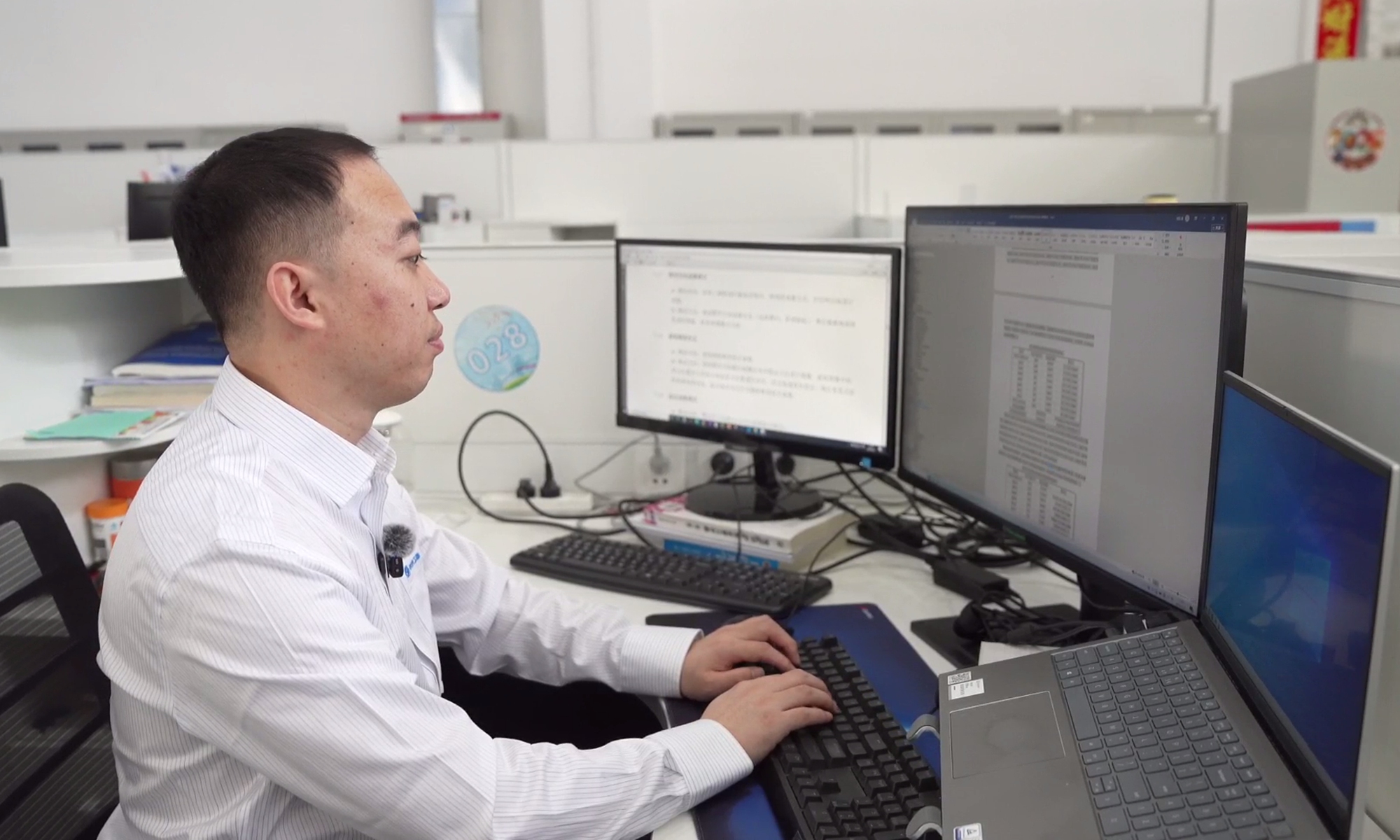
Qu Youyang, a post-90s satellite designer at the CGSTL, works on satellite equipment. Photo: Liu Yiqing/People's Daily
Editor's Note:
This year marks the 105th anniversary of the founding of the Communist Party of China (CPC) and the opening year of the 15th Five-Year Plan (2026-30). A new year begins with new resolve and new momentum. The call to "fight for our dreams and our happiness, and turn our great vision into beautiful realities" continues to inspire action across China.
In the column "New Year on the Frontlines," reporters from the People's Daily traveled to the grass roots to witness the vitality of a vast nation, see its mountains and rivers in motion and its fields in abundance, and listen to the stories of people finding fulfillment in both life and work.
Through these stories, the column seeks to present a vivid portrait of Chinese modernization.
"Centralized seminar, now commencing." At 9:30 am, red paper-cut horse decorations glinted on the office glass at Changguang Satellite Technology Co., Ltd (CGSTL), in Northeast China's Jilin Province.
Qu Youyang, a post-90s satellite designer in the CGSTL, and his colleagues huddled around computers: one displaying remote sensing images and analytical data transmitted back by a Changguang Jilin-1 satellite, another recording discussion notes, and a third for revising and debugging plans.
As the seminar wrapped up, the R&D team exchanged New Year greetings: "Wishing you all the joy and prosperity in the new year!" Having worked at the company for eight years, Qu's growth is vividly charted in "three images."
The first image is the ever-clearer and more precise remote sensing imagery.
What can a satellite capture at an altitude of 500,000 meters? Qu pulled up a photo. Roads, houses, and even the running track on the playground were clearly visible. "This," Qu said, pointing to a small building, "is the northernmost post office in our country."
In October 2015, the first four satellites of the Jilin-1 constellation developed by the CGSTL were successfully launched, marking the start of China's commercial aerospace industry. Qu joined the CGSTL in 2018. The welcome message from Zhong Xing, chief engineer at the CGSTL, was brief: "Make the satellites controllable and stable, and further upgrade the quality of satellite remote sensing services." At that time, making satellites "controllable" had already been basically achieved.
"To further make them 'stable,' we need to equip satellites with an intelligent brain," Qu explained. At 500,000 meters above the ground, even an attitude jitter of just a few arcseconds would cause the optical camera to deviate from its target, affecting image quality.
Analyzing movement trajectories, judging speed changes, and calibrating component positions - after countless tests and corrections, Jilin-1 satellites' image quality has steadily improved, with the positional error between actual and planned shooting points for a single scene now less than 1 meter.
The second image is a nighttime color photograph.
As we spoke, the reporter followed Qu walking out of the office. Qu pointed to a nighttime color image displayed on the large electronic screen in the lobby - a night view of Changchun Ice and Snow New World. Colorful lights in red, yellow, and green divided the park into distinct small zones. At the bottom of the image, the words "A world of ice and snow, right here in Changchun" formed by colorful neon lights were clearly visible.
"This is a nighttime color image captured by the Jixing Gaofen-07 satellite in January. With a resolution better than 0.5 meters, it is the first time for China's commercial aerospace satellites," Qu recalled. "When the photo reached the ground, the whole center erupted in cheers."
To implement the high-resolution nighttime light remote sensing program, Zhong, Qu and their colleagues developed ultra-stable attitude control technology with a large dynamic range. Combined with a series of camera optimization techniques, this has significantly improved the satellite's light sensitivity, enabling the capture of high-definition color satellite imagery at night.
The third image is a photo of Qu's postdoctoral research admission certificate.
As noon approached, instead of hurrying for lunch, Qu went out to pick up a delivery package. "These are professional books I ordered. I just can't wait to flip through them as soon as they arrive," he smiled shyly. "And now, I'm a postdoc." With the company's support, in 2021, Qu began pursuing a part-time PhD at the Changchun Institute of Optics, Fine Mechanics, and Physics, Chinese Academy of Sciences, focusing his research further on satellite‑ground integration.
As more satellites were developed, young engineers at the CGSTL were given greater responsibilities. "Just two or three years after joining the company, our young staff would get the chance to take charge of a satellite subsystem," Zhong said.
Qu became subsystem leader for the Jilin‑1 infrared satellite series in 2021, and subsystem leader for the Jixing Gaofen-07 satellite in 2024.
As of January, the CGSTL had developed and launched a total of 226 satellites, and the Jilin-1 constellation has imaged an accumulated area of 16.6 billion square kilometers. Transmitted from space day and night, satellite imagery serves agriculture, forestry, surveying, and mapping, among many other sectors.
"In the new year, I will continue to deepen my learning and practice, contributing to and creating value in this new track of commercial satellites," Qu said with firm resolve.
RELATED ARTICLES