IN-DEPTH / IN-DEPTH
GT reporters join mainland's first fishery scientific survey in waters east of Taiwan island, witnessing filling of gap in near-sea fishery research
Maiden expedition
By , Meng Xu and Fan Wei Published: Jul 25, 2026 12:48 AM

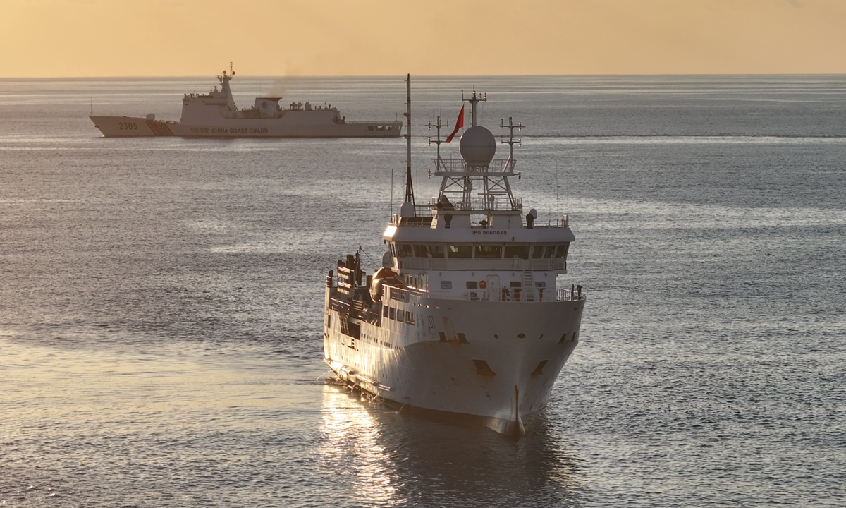
The Lanhai 201 scientific research vessel framed with the escorting China Coast Guard vessel 2305. Photo: Courtesy of Yao Yong
In the middle of a July night, in waters east of China's Taiwan island, the fishery science research vessel Lanhai 201 remained a hive of activity. As the survey nets were slowly hoisted aboard, the collected samples poured into specimen boxes, releasing a strong fishy scent. Yet Shi Yongchuang, an associate researcher at the East China Sea Fisheries Research Institute (ECSFRI) under the Chinese Academy of Fishery Sciences, China's Ministry of Agriculture and Rural Affairs, excitedly removed his mask and leaned in close to examine these small creatures from a relatively unexplored sea area.For the fishery survey team, whose average age is just 35, this marked their first survey of these traditional fishing grounds of Chinese fishermen. To them, it was a scientific expedition carrying forward a historic mission, and they felt proud to arrive in this sea area under Chinese jurisdiction amid turbulent waves.
On July 23, seven days after Lanhai 201 set sail, the comprehensive resource and environmental survey conducted by the ECSFRI in the waters east of Taiwan island was officially announced. The voyage covered the area of the waters east of Taiwan island within the range of latitudes 20.5°-23.5°N and longitudes 122°-124.5°E, and the Global Times reporters witnessed the whole expedition.
Zheng Hanfeng, chief scientist of the expedition and deputy director of the ECSFRI, told the Global Times that the most significant milestone of this voyage lies in filling the gap in China's fishery surveys in the waters east of Taiwan island, thereby completing the regional map of scientific investigations into fishery resources in China's exclusive economic zone.
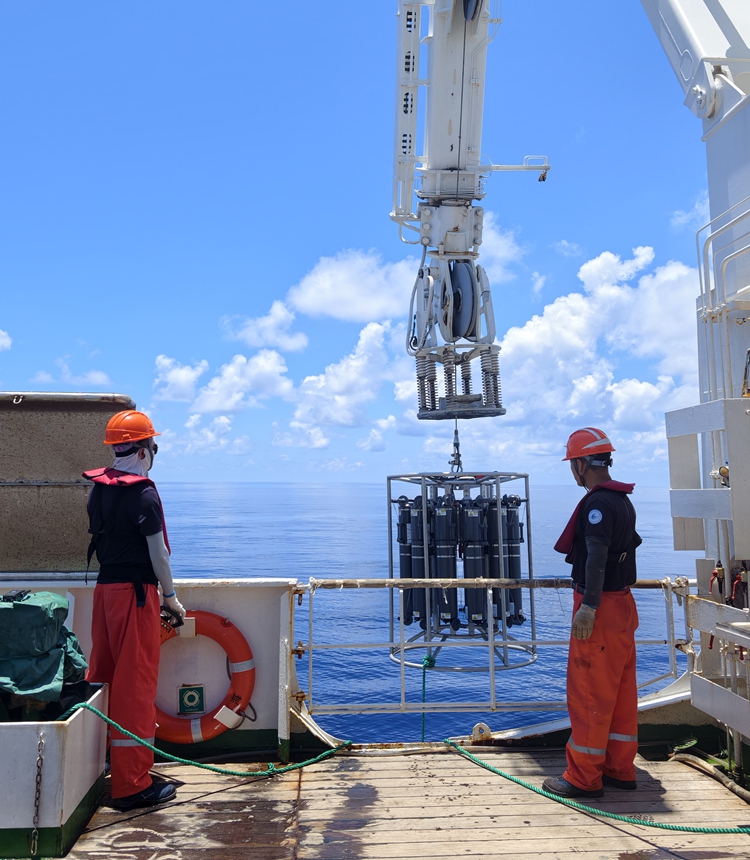
Scientific researchers and crew members survey fishing ground environments in waters east of Taiwan island on July 17, 2026. Photo: Hu Yuwei/GT
Filling gap in near-sea survey map"Non-stop work around the clock" was the norm for the survey team aboard Lanhai 201 over the seven days. Even after midnight, the decks and laboratories remained brightly lit. What excited the team were the hauls from each net. Like opening blind boxes, they looked forward to new surprises with every deployment.
Even for a small, ordinary-looking fish, Zhao Guoqing, another researcher, and his colleagues would carefully identify and clean it, measuring length and weight one by one, and meticulously dissecting to record gonad development and stomach fullness. He told the Global Times that these seemingly trivial basic biological parameters form the cornerstone for subsequent biodiversity analysis and resource assessment. The same fish species in different sea areas may exhibit significant differences in population characteristics due to geographic isolation and varying environments.
Zhang Hanye, a senior researcher at the ECSFRI in field of ichthyology taxonomy, told the Global Times, "The seabed in the waters east of Taiwan island features rare cliff-like depth changes, with depths reaching 3,000 to 5,000 meters, vastly different from the continental shelf characteristics of several dozen to over a hundred meters in other Chinese near-sea areas. Collecting first-hand data in this sea area under our own jurisdiction gives us much stronger confidence in scientific analysis."
This focus and dedication stem from a sense of mission. Zhao shared a regret with the Global Times: his supervisor had long participated in near-sea fishery resource surveys in earlier years. However, on the near-sea survey station map drawn by the team at the time, a small area remained blank - the waters east of Taiwan island. "My supervisor often said that only when we could conduct a survey there would the work be truly complete. This time, I have finally fulfilled the teacher's wish by filling that blank spot on the near-sea fishery survey map. As a Chinese person, I feel really proud right now."
Zheng also carries this sacred mission. He shared that 46 years ago, from 1980 to 1981, predecessors from the ECSFRI have taken Dongfang scientific vessel to conduct surveys in the outer region of the continental shelf and continental slope of the East China Sea, which is very close to today's research area. They completed 9 voyages and conducted over 110 stations, covering a total area of more than 30,000 square nautical miles. Yet due to various factors, this particular area was left blank. "I feel honored today to come here with a new generation of colleagues for scientific investigation. It is both a continuation of the legacy and a remedy for the past regrets," said Zheng.
In this sea area rarely visited by mainland fishery workers, the survey team found a very rich biota. Preliminary identification revealed approximately 114 fish species, eight cephalopod species, and six shrimp and crab species.
Meanwhile, this area also showed extraordinary diversity and abundance of ichthyoplankton, and plankton species richness and biomass are exceptionally high as well. Chen Yuange, an assistant researcher at the ECSFRI and the leader of the expedition's plankton team, extended the scientific survey into the microscopic world. Most of the time, he examines ichthyoplankton samples under a stereomicroscope, consulting literature on the early life history of this area and carefully cross-referencing specimens with their characteristics. "The waters here are so biologically rich that our expedition findings could well fill a book someday," he said confidently.
"The waters east of Taiwan island are part of China's exclusive economic zone under jurisdiction and serve as traditional fishing grounds for fishermen from Taiwan. They are rich in high-value species such as tuna, as well as dolphinfish, mackerel, scad, squid, and other economically important fish," Zheng explained. Moreover, literature indicates that this sea area is one of the important spawning grounds for Pacific bluefin tuna, the only known bluefin tuna spawning ground located within China's exclusive economic zone. For a long time, however, it remained one of the very few areas in China's EEZ that had not undergone systematic fishery resource surveys. Conducting investigations here holds profound significance for understanding the life history of these high-value fish and expanding aquaculture and breeding research, according to this chief scientist.
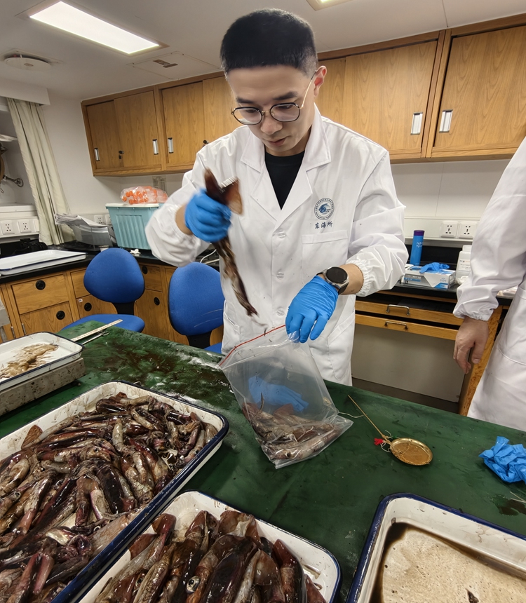
A scientific researcher at the ECSFRI studies squid specimens on July 18, 2026. Photo: Hu Yuwei/GT
"From publicly available literature, previous surveys in this sea area conducted by China's Taiwan island, Japan, and the Philippines mainly focused on individual economically important species such as bluefin tuna. But we are not limited to single species. A systematic fishery resource survey like ours - covering multiple stations, multiple species, and strictly following national standards - is the first of its kind in this sea area," Zheng further noted.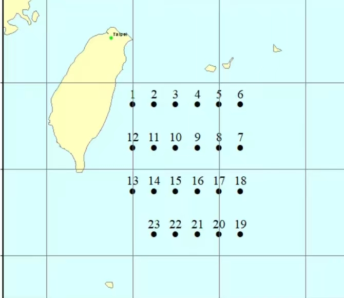
Map of survey stations for the Lanhai 201 fishery scientific research Photo: Courtesy of ECSFRI
Undeterred by rough waves and harassmentTwo days after departure, Beaufort wind at force eight stirred up 5-meter swells, causing the 3,000-ton-plus Lanhai 201 to roll more than 15 degrees. Not only the Global Times reporters, who were experiencing the sea's power for the first time, but also many seasoned crew members felt dizzy and nauseous.
Yet the rough seas could only be overcome by passion. The reporter observed during the voyage that no matter how complex the sea conditions, once the vessel reached a preset station, upon hearing the winch lowering the nets and seeing the gleaming catch under the searchlights, the scientific team could overcome seasickness.
If searching for marine specimen could soothe physical discomfort, facing external harassment strengthened the team's resolve.
Recently, Japan and the Philippines bypassed China to unilaterally initiate so-called maritime delimitation negotiations in the waters east of Taiwan island, openly infringing on China's maritime rights and interests. Before departure, some team members gained a deeper understanding of the unique significance of this voyage.
During the seven-day journey, external forces intending to interfere with the Chinese survey arrived as expected. Not only did military aircraft from a certain country circle above Lanhai 201, but the Japan Coast Guard also dispatched a patrol vessel to shadow the research ship. However, these interferences did not disrupt the survey's rhythm; instead, they further strengthened the team's determination to complete the scheduled tasks in this sea area.
One notable incident occurred on July 18. During survey operations that day, the radar on the Lanhai 201 showed the Japan Coast Guard's PLH42 Shunko patrol vessel attempting to approach the Chinese research ship. Meanwhile, China Coast Guard (CCG) vessel 2305, performing routine law enforcement patrols in nearby waters, remained highly vigilant and firmly intercepted the Japanese vessel, keeping it outside the 14-nautical-mile range of the research ship, making it difficult for the Japanese vessel to close in.
That evening, the Global Times reporter saw via radar imagery that another CCG vessel 1401, also rushed to the scene to join the escort. The two vessels formed a protective formation, securely shielding Lanhai 201. Witnessing this, Chen sighed with relief: "The moment I saw the CCG ships appear on the radar, I felt completely at ease."
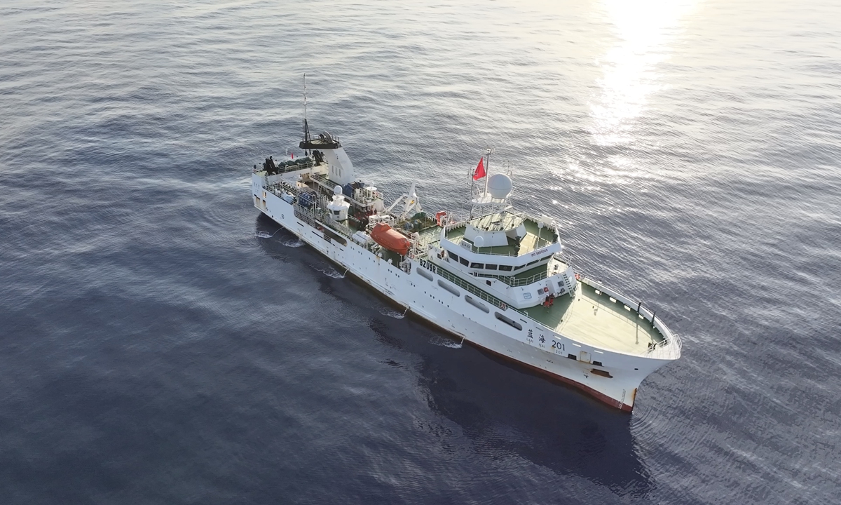
The Lanhai 201 scientific research vessel conducts fishery resource surveys in waters east of Taiwan island. Photo: Courtesy of Yao Yong
Protecting fishery rights is defending maritime rights"Fisheries represent one of humanity's oldest uses of the ocean and one of the primary ways to exercise maritime rights. Countries' assertions of maritime rights and interests are largely manifested in claims over fishing grounds and fishing rights," Zheng said during the voyage, highlighting another dimension of the survey's significance. "This survey itself is an important measure to exercise jurisdiction and demonstrate national sovereignty."
The focus of this survey is fishery resources and fishing ground environments. Zheng believes that the survey is for better protection and sustainable utilization, which is itself a manifestation of safeguarding maritime rights and interests.
"Fisheries, due to their unique flexibility, widespread nature, and mass participation, play an irreplaceable role in maintaining national maritime rights and interests," Wang Nan, an associate professor at the School of Marxism, Beijing Jiaotong University, who researches maritime history, told the Global Times.
Fisheries are also an important area for countries to expand diplomacy, participate in international resource allocation and management, and handle international relations. "China should attach greater importance to striving for and safeguarding fishery rights, by strengthening the actual presence of fisheries in disputed waters and establishing dominance in certain sea areas, thereby achieving the effect of declaring and exercising sovereignty," Wang said.
RELATED ARTICLES