How Xizang builds space-air-ground flood defense network via technologies in the wet season
From glaciers to villages
By Published: Aug 04, 2026 09:40 PM

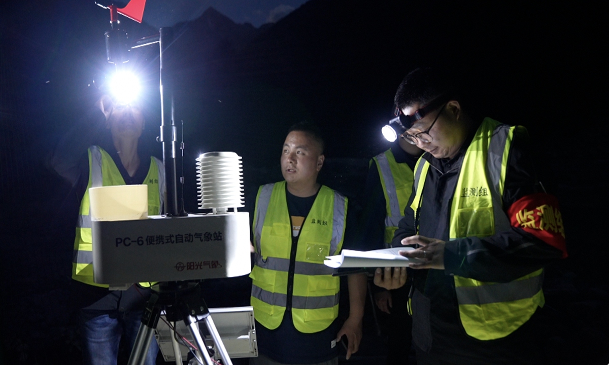
A portable automatic weather station is used during an extreme flood simulation drill in Zayu County, Nyingchi, Xizang, on May 29, 2026. Photo: Courtesy of Jing Wenli
A hand-cranked alarm broke the darkness in a village in Zayu County, Nyingchi city, Southwest China's Xizang Autonomous Region.
In the scenario unfolding that night, prolonged rain had pushed a mountain stream above its orange-alert level. Power, telecommunications and road access had all been cut. A drone carrying lighting equipment rose above the village, illuminating the flood-monitoring point and an evacuation route as emergency teams assessed the danger and went door to door to move residents.
The emergency was simulated. The difficulties it tested were not.
Contrary to common perceptions of Xizang in southwestern China as uniformly high, cold and dry, parts of the region are no strangers to heavy rainfall and flooding.
Zayu County, for example, sits at an average elevation of about 2,300 meters and receives 764.5 millimeters of precipitation annually, with terrain descending from snow-covered mountains into humid subtropical valleys.
On Monday, Xizang regional meteorological observatory also issued an orange alert for lightning, warning of thunderstorms across much of Xigaze and western Nagqu, as well as central, eastern and western Lhasa and central and western Shannan, with localized downpours, thunderstorm gales and hail.
In a plateau region cut by deep valleys and high mountains, flood control involves more than watching a river rise. Heavy rain can trigger mountain torrents, landslides and debris flows. A slope failure can block a river and form a barrier lake, while changes in glaciers and glacial lakes can create risks far downstream.
Xizang is therefore building a monitoring chain that combines satellites in space, drones in the air and sensors and people on the ground. Nyingchi's current flood-season operations show how those layers are being connected - and why the final step still depends on whether a warning reaches a village in time.
Seeing risk earlier
Across Nyingchi, 143 automatic rainfall stations and 60 integrated rainfall-and-water-level stations now provide real-time data on precipitation and river conditions, according to the information provided by the Nyingchi Water Resources Bureau to the Global Times.
The stations form the fixed ground layer of the system. Mobile inspections add another view. During the flood season, water officials combine on-foot checks with drone surveys of mountain rivers, remote slopes and ravines that are difficult or dangerous to inspect fully from the ground.
Images collected from above are used to identify loose slopes, blocked drainage channels, weak embankments and other less visible risks. Inspectors register and photograph each problem, assess its cause and possible impact, and assign responsibility and a deadline for corrective work.
The approach in Nyingchi is part of a wider expansion of Xizang's observation network. By the end of 2025, the region had 1,284 ground weather stations, while the share of the population covered by weather radar had risen from 32.6 percent in 2020 to 73.7 percent. A high-resolution forecasting system can update forecasts every six minutes for the coming two hours. The lead time for severe convective-weather warnings in places including Lhasa and Shannan has reached 39 minutes, according to the regional government.
The space-based layer becomes particularly important where roads are sparse and glacial terrain is difficult to reach. Xizang has built 12 automatic weather stations in representative cryosphere zones and uses data from Fengyun and Gaofen satellites to routinely monitor key glaciers, lakes and glacial lakes, according to local government.
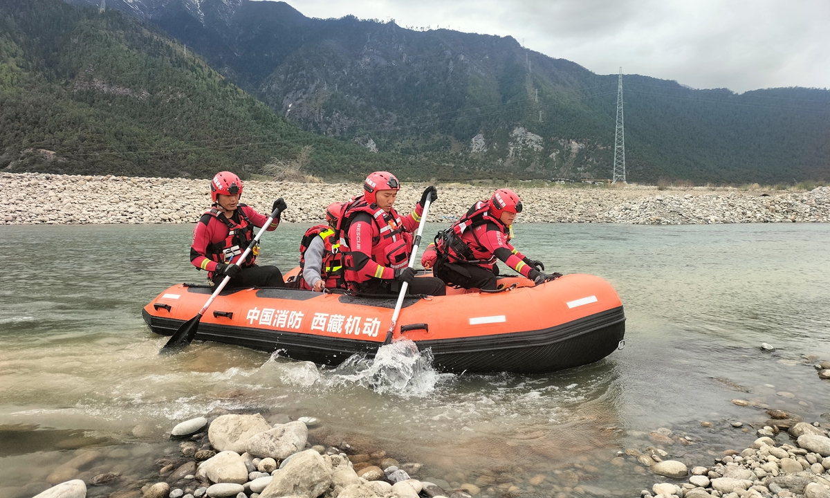
An emergency drill simulating a flood exceeding design standards is held along the Niyang River in Nyingchi, Southwest China's Xizang Autonomous Region. Photo: Courtesy of Ma Chuanqiu
In Ngari, natural resources authorities have combined Chinese high-resolution satellite data with overseas remote-sensing data to develop a continuously operating glacier-monitoring system. It tracks changes in glacier movement, cracks, area and elevation.For selected glaciers, that broad view is checked against automatic weather stations, high-definition time-lapse cameras, ground-penetrating radar and drone surveys. Together, the instruments collect information on weather conditions and changes at glacier surfaces and termini, helping specialists identify glaciers undergoing rapid change and issue risk warnings. Ngari has 19,507 glaciers, covering more than 5,151 square kilometers, according to regional authorities.
The different layers perform different tasks. Satellites can screen a vast and inaccessible area for change; drones can inspect a slope or channel at closer range; and rainfall and water-level stations show conditions developing in real time. Ground teams then determine what the signals mean for roads, homes and people below.
From warning to movement
In Nyingchi, the next part of the chain begins with two people in each village.
The city has added the heads of village-based work teams to a warning-response system that already includes village Party chiefs. When a warning is issued for a flash-flood-prone area or another risk point, the dual-channel "call-and-response" arrangement is intended to ensure that someone receives the message, confirms it and carries out the instruction.
Across Xizang, 685 township-level meteorological information service stations help warnings reach communities. During the 14th Five-Year Plan period, the public coverage rate of meteorological warnings rose from 65 percent to 98.7 percent. A targeted warning system has also been developed for 21 border counties, where scattered settlements and difficult terrain can make mass communication harder, according to the Xizang Business Daily.
But receipt of a message is only the beginning. Officials must know which households are exposed, where residents should move to and whether the route remains usable in darkness or heavy rain.
That is why Nyingchi's counties have designed drills around different local hazards. In Medog County, an exercise simulated continuous rainfall triggering a landslide that blocked a river and formed a barrier lake threatening downstream townships. The drill ran from the first report and emergency command through monitoring, evacuation, resettlement and a final review.
Gongbo'gyamda County added a glacial lake outburst scenario to its exercise for the first time.
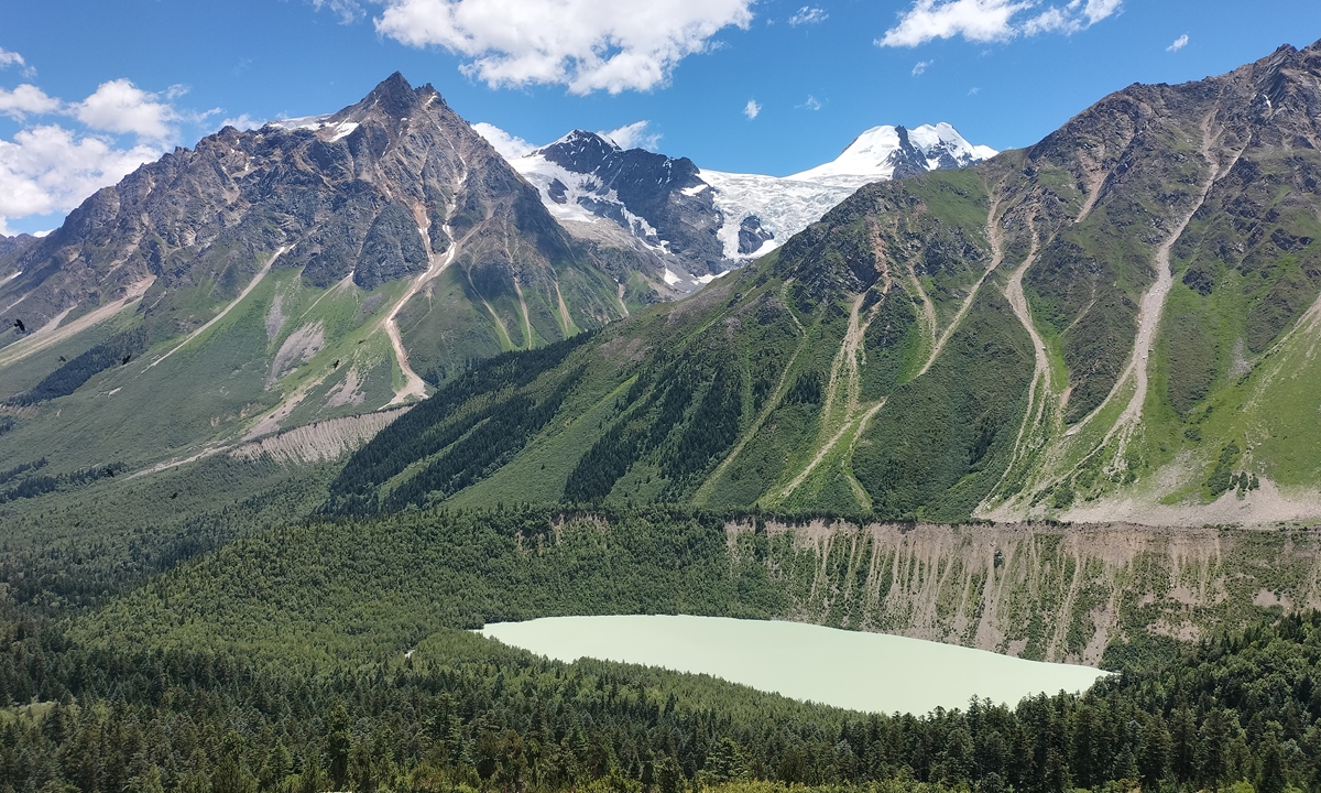
A view of Chunjicuo Lake in Zayu County, Nyingchi, Southwest China's Xizang Autonomous Region Photo: Courtesy of Nyingchi Water Resources Bureau
Zayu's nighttime drill deliberately assumed that electricity, communications and roads were all unavailable. Before the exercise, technicians taught villagers to recognize signs of a mountain flood, including a sudden rise in water, muddy flow, a roar upstream and turbid water seeping from a slope.At 9 pm, the drone did more than inspect the flood channel. Its lights also marked the evacuation route. Communications teams worked to restore contact, road crews cleared access and evacuation teams moved from household to household, with special arrangements for older people, children, people with illnesses and residents with disabilities.
Water officials are also checking the systems that must function before an evacuation order is given. Inspection teams have visited reservoirs, hydropower stations, construction sites, villages and identified mountain-flood risk zones.
They have checked to ensure reservoirs retain sufficient flood-control capacity, automatic stations remain online, village alarms work and also that evacuation sites listed in local emergency plans are usable.
"The critical flood-control period from late July to early August is the top priority of the year's flood and drought disaster prevention work," Quan Baowei, director of the Nyingchi Water Resources Bureau, told the Global Times.
Quan said the city is working to close gaps in grassroots flood-control systems and strengthen its overall capacity to defend against mountain floods.
The nighttime exercise in Zayu compressed that system into a few minutes: a water-level signal, an alarm, a drone lighting the route and teams moving from house to house. Each piece served a different purpose. The test was whether they could work as one chain before water reached the village.
RELATED ARTICLES