Climate Gambit: Chinese team develops ‘super brain’ to guide flood precautions using weather, hydraulic and terrain data
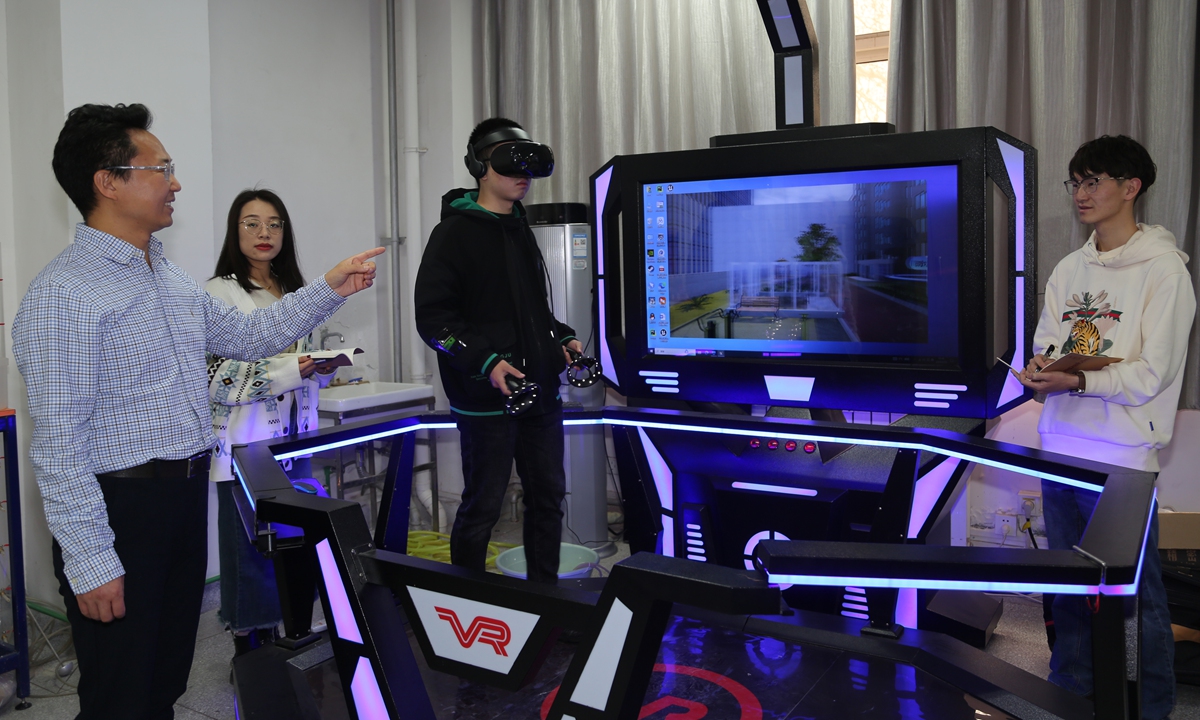
Students from Xi'an University of Technology test a virtual reality-enabled emergency evacuation simulation system tailored for flood disasters on January 12, 2024. Photos: Courtesy of Xi'an University of Technology
Editor's Note:Extreme weather is increasingly a global challenge, and the key to addressing climate risks lies in earlier prediction, more precise action and smarter preparedness, with emerging technologies playing a vital role. The Global Times launches the "Climate Gambit" series, exploring how research teams are leveraging cutting-edge technologies, including artificial intelligence, high-performance computing and smart observation systems, to anticipate weather changes, enhance disaster early-warning and strengthen resilience against climate risks.
Inside a state key laboratory at Xi'an University of Technology, Northwest China's Shaanxi Province, there is a miniature but complete "water world" which simulated water channels, inland lakes and main rivers to recreate real flood scenarios and test their newly developed GPU Accelerated Surface Water Flow and Transport Model (GAST).
Known as a "super brain" for flood control, GAST can complete flood simulations involving more than 3 million computational units within 30 seconds, helping transform flood management from a reaction to emergency into active precautions since "flooding impacts can be predicted even before rainfall arrives."
At a time when extreme rainfall and summer flooding have become increasingly frequent, questions such as when the flooding will arrive, which roads may be submerged and when residents should evacuate have become increasingly important.
In an exclusive interview with the Global Times, Hou Jingming, a professor at Xi'an University of Technology and the leader of the research team, explained how the GAST model seeks to answer these questions by accurately predicting flood development and identifying vulnerable areas before disasters occur, and how the model helps authorities take preventive measures to reduce casualties and economic losses.
AI empowering 'flood drill'
The water tank system in the lab was designed to create a controllable, repeatable and observable environment to simulate complex hydrological processes, including river flooding, urban water level changes, lake regulation, drainage pump operations and coordinated flood-control measures.
By adjusting variations such as upstream water inflow, rainfall intensity, downstream water levels and drainage conditions, scientists can recreate different flood scenarios. Meanwhile, water levels, flow speeds and other data are collected in real time and displayed on a digital twin platform.
"If a rainstorm and corresponding floods are an exam, GAST is like a 'drill,'" Hou said. "It can simulate how floods develop, where water will flow, which areas may be inundated and when river levels may rise, ensuring authorities are well but not overly prepared."
To answer the public's concern about "whether my neighborhood will be flooded when heavy rain arrives," the team developed new algorithms for urban surface water flow, including improvements in terrain slope and friction calculations.
These breakthroughs have improved simulation accuracy in complex urban environments. Compared with extensive monitoring data, GAST can keep simulation errors of key hydrodynamic factors within 15 percent. This means the model can provide not only general flood trends, but also quantitative information such as water depth, flow speed and inundation areas.
Combined with AI technologies, it can identify complex relationships between rainfall, water conditions, flood depth, flow velocity and affected areas, cutting simulations from hours in traditional methods to minutes or even seconds.
The faster calculation capability means that once meteorological authorities update forecasts, the model can quickly estimate flood risks in different parts of a city.
"The earlier rainfall warnings are issued, the earlier we can identify potential flooding hotspots and high-risk areas," Hou said. "This saves valuable time for evacuation, traffic management and emergency deployment."
For smarter disaster response
Building an accurate flood prediction model also requires integrating large amounts of urban data other than weather forecasts, including urban terrain, drainage networks and infrastructure information.
For example, a model developed for Xi'an incorporates geographic data and drainage system information collected from relevant authorities and field surveys. After receiving rainfall forecasts, the system can quickly calculate possible flooding scenarios, showing when and where waterlogging may occur and highlighting vulnerable roads and areas through visual maps.
To demonstrate how the super brain works in case of possible flooding, the laboratory has set a virtual reality area where visitors can experience a simulated urban flooding evacuation in the Xiaozhai area of Xi'an. Wearing VR headsets, participants can see water levels gradually rising and follow emergency instructions to move toward higher ground.
The entire technological package has already been applied in real-world flood prevention.
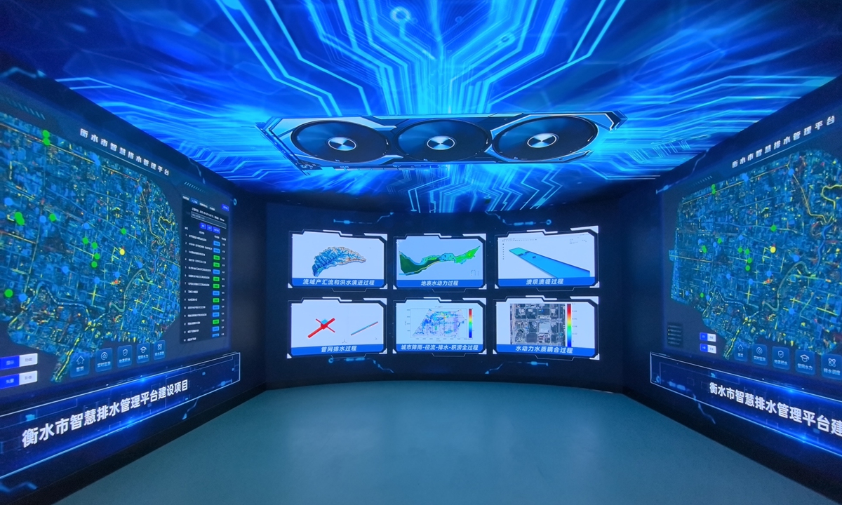
A 3D live-scene display lab in Xi'an that oversees stormwater drainage performance in Hengshui, North China's Hebei Province Photos: Courtesy of Xi'an University of Technology
During Typhoon Muifa in 2022, Haishu district in Ningbo, East China's Zhejiang Province, recorded a regional rainfall of 367 millimeters. Using GAST as its core technology, the local flood forecasting platform integrated weather forecasts, AI algorithms and real-time monitoring data to provide rolling three-hour flood risk predictions.
Post-event assessments showed that predicted risks at most locations matched actual flooding conditions. The average relative error between predicted and observed maximum water depths was 13 percent.
The GAST model was also integrated into a smart rain and flood management platform in Qinhan new city area in Xianyang of Shaanxi, and during a rainstorm warning in July 2022, the platform provided continuous monitoring and forecasts. Based on the results, local authorities shifted from routine inspections to targeted monitoring of flood-prone areas and optimized emergency drainage operations.
The model is also being applied to mountain torrent prevention, as it can simulate rapidly changing flows in complex terrain and, combined with machine learning, complete forecasts within seconds. For reservoirs and rivers, it supports sudden and gradual dam-break simulations.
In June 2026, the model was presented at a national symposium on flood risk mapping achievements. The technology has since been applied by water resources, emergency management and urban development authorities, expanding from Shaanxi to multiple provinces and regions across China.
Looking ahead, the research team is developing a framework that further keeps up with the pace focusing on AI technologies. "Currently, the system operates based on weather forecast, therefore, AI will increase efficiency by using historical cases and real-time monitoring data to correct errors and update forecasts dynamically," Hou said.
RELATED ARTICLES