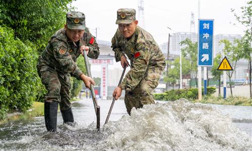
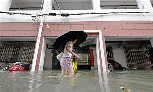
Typhoon Dolphin’s remnants continue to drench broad swathe of China, bringing torrential rains to East China, Huanghuai and North China

Residents ride electric bicycles through floodwaters caused by heavy rain from Typhoon Dolphin’s remnants in Zhengzhou, Central China’s Henan Province, on August 12, 2026. Photo: IC
Typhoon Dolphin, the 13th typhoon of the year, weakened into a tropical depression over Central China’s Hubei Province on Monday and was subsequently declassified by the National Meteorological Center (NMC). However, its remnants continue to bring significant rainfall risks. Combined with incoming cold air, the system is expected to trigger heavy rain across East China, the Huanghuai region and North China over the next three days, with some areas facing high risks of rain-triggered disasters.
The NMC continued its orange alert for heavy rain and blue alert for severe convective weather on Wednesday morning. At 6 pm on Tuesday, the Ministry of Water Resources and the China Meteorological Administration (CMA) jointly issued a red warning for flash floods, while the Ministry of Natural Resources and the CMA jointly issued an orange risk warning for geological disasters, China’s state broadcaster China Central Television (CCTV) reported on Wednesday.
Around Wednesday, the typhoon’s remnants are expected to stall near the border area of Hubei, Henan and Anhui provinces, interacting with an upper-level trough and cold air to bring another round of widespread heavy rain, People’s Daily reported on Wednesday.
At the center of the heavy rainfall, parts of central and eastern Henan were hit by torrential to exceptionally heavy rain on Tuesday, with extreme rainfall reported locally in Pingdingshan and Luoyang. More heavy rain is forecast from Wednesday through Saturday, with parts of central and western Henan at risk of exceptionally heavy to extreme rainfall. The provincial flood control and drought relief headquarters activated a Level II emergency flood-control response at 8 am on Wednesday, per the CCTV report.
The Henan provincial meteorological observatory upgraded its heavy rain warning to red at 7:30 am on Wednesday. Parts of multiple cities including Luoyang, Zhengzhou and Zhoukou have seen exceptionally heavy rainfall, with Changcun village in Yexian county recording a maximum of 356.9 millimeters.
In response, China’s State Flood Control and Drought Relief Headquarters and the Ministry of Emergency Management decided to raise the Level IV emergency flood-control response for Henan to Level III at 9 am on Wednesday.
Sun Qianqian, a CMA meteorological analyst, explained that as the moisture carried by the typhoon reaches Henan, the Taihang and Funiu mountains will act as a barrier, forcing the moist air to rise and significantly amplifying precipitation.
The arrival of cold air is expected to further fuel severe convection, unleashing the system’s remaining energy and moisture, CCTV reported.
The combination of the typhoon’s remnants and cold air can produce even heavier rain than the typhoon itself. With saddle-shaped weak steering currents between high-pressure systems to the east and west, Typhoon Dolphin’s residual low-pressure circulation is expected to stall over Henan and Hubei provinces, prolonging the rainfall, according to CCTV.
After Typhoon Dolphin’s remnants moved into Hubei, strong winds and heavy rain hit parts of the province, with Xiangyang, Shiyan and Suizhou among the hardest-hit areas, CCTV reported.
Since China’s State Flood Control and Drought Relief Headquarters and the Ministry of Emergency Management activated a Level IV flood-control emergency response for Hubei on Monday, more than 25,000 people had been relocated from affected areas by Tuesday noon, Hubei Daily reported on Wednesday.
Heavy rain has increased flood-control pressure in Xiangyang, where 125 reservoirs have exceeded normal water levels. More than 10,000 people had been relocated by Tuesday evening, while 266 rescue teams with 9,087 personnel have been deployed and more than 170,000 emergency relief supplies prepared, according to Hubei Daily.
Hubei has dispatched experts and working teams to key areas including Xiangyang and Shiyan. Some 27,800 emergency personnel and 16,400 sets of rescue equipment have been pre-positioned in areas facing heavy rain, Hubei Daily reported.
Moreover, heavy rain is expected to continue in Beijing from Wednesday morning through Thursday daytime, with the most intense rainfall occurring from Wednesday morning through the day. The rain was forecast to gradually weaken starting Wednesday night, CCTV reported.
According to Xue Li, director of the flood control and drought relief division of the Beijing Emergency Management Bureau, rain began spreading across Beijing around Tuesday noon, with Shifosi village in Yanqing district recording the city’s highest rainfall of 175.4 millimeters between noon and 9 pm, CCTV reported.
Beijing activated a citywide Level II flood-control emergency response at 9 am on Tuesday. Districts of Fangshan and Mentougou were placed under a strengthened Level I response, while eight other districts, including Changping and Tongzhou, activated Level I flood-control responses.
In addition, the capital city had evacuated all residents identified as being at risk by 6 pm on Tuesday. As of 9 pm on Tuesday, Beijing had closed 151 tourist attractions and 157 camping sites, suspended more than 4,100 rural B&B operations, evacuated or turned back over 1,300 tourists, and halted work at more than 3,300 construction sites.
Heavy rain also hit many parts of Tianjin Municipality on Wednesday, disrupting air travel. By 12:30 pm, the Tianjin Binhai International Airport had canceled four flights and delayed 13, with services to Chengdu, Guiyang and Kunming among the hardest hit.
Global Times
RELATED ARTICLES