Barrier lake upstream of Gyirong Port holds over 2.5 million cubic meters, faces risk of overflow: report
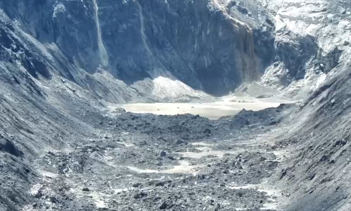
The barrier lake formed upstream of Gyirong Port after a mudslide hit the port in Southwest China's Xizang Autonomous Region. Photo: Lhasa Fire and Rescue
A barrier lake that formed upstream of Gyirong Port following a mudslide triggered by a high-altitude glacial collapse has begun to overflow, according to the latest update, CCTV News reported on Friday.
The water area of the barrier lake continues to expand, with unstable landslide masses visible on both sides, and is currently estimated to hold more than 2.5 million cubic meters of water.
Authorities said the lake faces a relatively high risk of breaching, which could trigger further disasters downstream, and relevant departments are continuing to closely monitor the situation, according to CCTV News.
A panoramic view of the barrier lake was captured from Guoba village in Sale township, Gyirong county. The village is located on elevated, relatively flat terrain on the northern slope of the Donglin Zangbu River valley, about 150 to 200 meters above the valley floor, allowing a view of the barrier lake on the opposite side.
According to the latest monitoring, the barrier lake is located at an elevation about 1,000 meters higher than Gyirong Port. As the lake continues to overflow, it could potentially trigger new flash floods or mudslides, making operations in the key search-and-rescue areas extremely dangerous, CCTV reported.
On Thursday, China Anneng Construction Group dispatched an eight-member advance team equipped with portable satellite communication stations, reconnaissance drones and other equipment to conduct aerial surveys and three-dimensional modeling of the barrier body upstream. The data will provide scientific support for subsequent measures to deal with the barrier lake.
Chen Hanxiao, a member of the reconnaissance team, said that one of the major challenges was the inability to approach the barrier lake directly, according to CCTV News.
"There are many isolated cliffs and steep slopes along the lake, making it difficult for personnel to reach the area. Heavy machinery, including excavators, also faces difficulties in reaching the top of the barrier," Chen said.
On Thursday, the team conducted aerial photography and three-dimensional modeling of the barrier body using drones from a location about six kilometers away from the barrier lake.
Chen said that, in general, authorities can deal with a barrier body by excavating a drainage channel at a lower point to release accumulated water. The data collected during Thursday's reconnaissance will provide scientific support for subsequent operations.
"According to our preliminary measurements, the barrier body is about 150 meters long and 40 to 50 meters high, and the barrier lake has a large storage capacity," Chen said.
Continued rainfall has left rocks and soil along the affected area loose and unstable. During the reconnaissance mission, secondary collapses occurred several times above the barrier body.
Following consultations among relevant authorities and experts, the current plan is to continue real-time monitoring of the barrier body, Chen said. On Friday, the team planned to carry water-monitoring equipment and approach the barrier body on foot to conduct further surveys of the lakebed and water storage capacity.
Over the coming days, authorities will closely monitor weather conditions, the rate at which the lake's water level rises, and the condition of the landslide masses above the barrier body, Chen said.
With more rain forecast over the coming days, the barrier lake could experience small-scale breaches, potentially posing a threat to emergency rescue and disaster-response operations downstream, the expert said, per CCTV News.
Global Times
RELATED ARTICLES