Exclusive: Traditional warning insufficient, remote sensing of slopes needed as ice-rock avalanche risks on the rise: intl experts
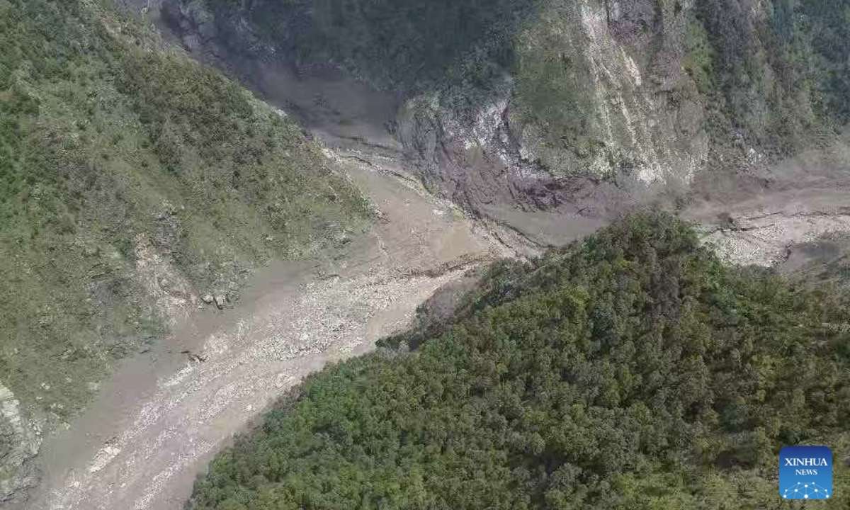
This photo taken on Aug. 26, 2026 shows a view of the mudslide-hit area. Three people had been killed and 265 others remained missing as of 8 p.m. Wednesday after a mudslide struck Gyirong port along the China-Nepal border in southwest China's Xizang Autonomous Region, officials said. (Xinhua)
The devastating mudslide that swept from Nepal's Mount Langtang Lirung to China's Xizang Autonomous Region in minutes highlights the growing challenge of detecting and warning against fast-moving ice-rock avalanche disasters in the Himalayas, international experts told the Global Times, warning that such events could become more frequent as glaciers and permafrost destabilize under a warming climate.
An ice-rock avalanche originating from a high-mountain glacier in Nepal triggered the disaster that struck Gyirong Port on August 26, according to an assessment by Chinese authorities. A glacier on the north slope of Mount Langtang Lirung fractured at an altitude of about 5,200 meters, sending an avalanche rapidly down to around 4,000 meters, where it scoured the mountainside and transformed into a massive debris flow. The flow traveled about 22 kilometers before reaching Gyirong Port, at an altitude of around 1,800 meters, Xinhua News Agency reported.
The disaster was exceptionally rapid. The debris flow reached the port only about six to seven minutes after the initial collapse, according to researchers cited by Xinhua.
Jakob Steiner, a geoscientist at the University of Graz in Austria, told the Global Times that satellite imagery and the depth of the scar indicate that the event may have begun with a bedrock failure, rather than instability of the glacier itself.
"The ice just added material and likely contributed to the flood wave and extent," Steiner said
Steiner also stressed that longer-term environmental changes and instability of the slope were likely more important than the short-term melting of snow and ice observed before the collapse. The recent melt may have acted as the final trigger, he said, while the slope could otherwise have failed somewhat later.
Kristen Cook, a geomorphologist at the Institute of Earth Science at Grenoble Alpes University in France, similarly told the Global Times that the bedrock collapsed first. Given the relatively small size of the glacier compared with the rock mass involved, she said, glacial instability was unlikely to have had a major influence on the initial failure.
Cook said the slope's long-term stability would have been influenced by a combination of climate warming, geological processes and tectonic activity, although research into these factors is still underway.
The event also challenges conventional classifications of high-mountain disasters, according to the experts.
The Langtang Lirung event was very similar to the deadly 2021 Chamoli disaster in India's Uttarakhand, Cook said, rejecting descriptions of the August 26 event as a glacial lake outburst flood, or GLOF, she noted.
"It was a rock/ice avalanche that continued flowing down the valley after the initial collapse," she said, adding that there was no initial damming and breaching involved in the event itself. The distinction is important for disaster preparedness because a destructive flood-like event can occur without a glacial lake, Cook said.
Both experts mentioned the 2021 catastrophic mass flow descended into valleys in Chamoli of Uttarakhand state in India, causing widespread devastation and severely damaging two hydropower projects. Over 200 people were killed or missing.
Steiner identified Chamoli as the closest comparison to the Langtang Lirung event in terms of the processes involved, although the volumes and terrain differed.
The disaster therefore underscores the need to broaden hazard assessments beyond conventional GLOFs and other relatively familiar glacier-related hazards, experts said.
The biggest challenge, however, may be detecting such events early enough before they happen.
Cook said there are currently no operational early-warning systems based on seismological monitoring for this type of event, while satellite-based early-warning systems are also not yet widely operational.
Hydrological monitoring has its own limitations. Instruments installed alongside rivers can be destroyed by the very floods they are supposed to detect. Even when they survive long enough to record the beginning of a flood, they may not be able to determine its magnitude quickly enough to provide useful information to downstream communities, Cook said.
Steiner said detection is "very tricky," noting that even when a potentially dangerous signal is detected, experts still need to interpret it. Excessive reliance on raw signals could otherwise generate too many false alarms.
Instead, analyzing satellite imagery for concerning patterns before a collapse may prove more useful, he said.
Cook advocated developing automated slope-deformation monitoring using remote sensing, which could provide a more practical way to identify unstable slopes in remote high-altitude terrain.
For Steiner, this disaster should not be regarded as an isolated extreme event.
"We unfortunately definitely see this as an emerging pattern," he said. "It is not an isolated event any more and we need to be prepared to see it more often."
Cook offered a more nuanced assessment. While the Langtang Lirung event was extremely large, she expected more rock/ice avalanche-related flood cascades across High Mountain Asia in the future, although most would likely be considerably smaller.
She noted that even a collapse 100 times smaller than the Langtang Lirung event could potentially generate a disastrous flood, citing the 2023 mudflow in Shovi, Georgia, as an example.
"The key is to develop automated slope deformation monitoring using remote sensing," Cook said.
The combination of high-altitude source areas, steep terrain, rapid transformation and extremely short warning windows means that conventional disaster-warning approaches may not be sufficient, experts said.
RELATED ARTICLES