ARTS / CULTURE & LEISURE
Is the world map about to change? New projections reshape how we see the world
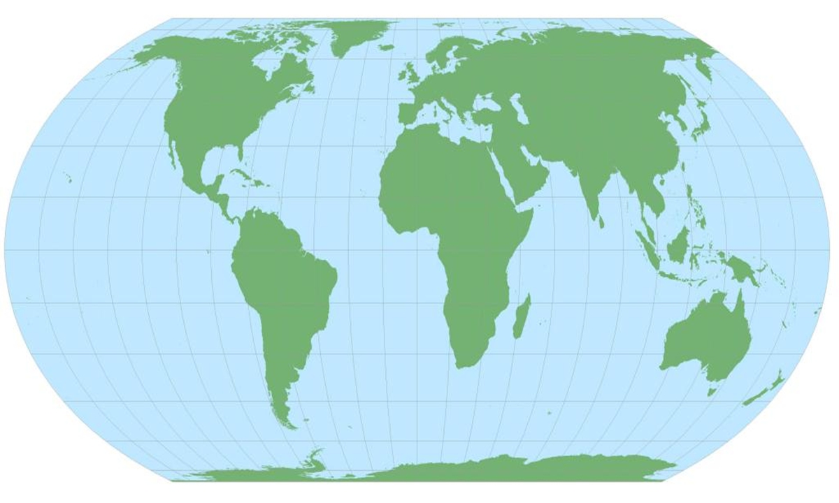
Equal Earth projection map. Courtesy of SinoMaps Press.
On the world maps most of us have seen since childhood, Greenland looks almost as big as Africa. But Africa is actually about 14 times larger, and Russia and Canada also appear far bigger than their true size. That does not mean the maps are simply "wrong."
It reflects a basic problem: Earth is round, but the maps we use are flat. How we turn a three-dimensional globe into a flat map can change how we see the size and shape of places around the world.
Recently, that question has gained fresh attention after the United Nations General Assembly adopted a resolution encouraging greater use of the Equal Earth projection, which represents the relative sizes of continents more accurately. The resolution was initiated by the African Union and passed with 164 votes in favor, one against and six abstentions.
The move has put the familiar Mercator projection back in the spotlight. Widely used for centuries, the Mercator projection makes areas near the poles appear much larger than they actually are.
"It would be too simplistic to say that one map projection is right and another is wrong," Zhao Juan, a senior editor at Chinese Map Publishing House, told the Global Times. "Map projections are essentially about making trade-offs among angles, area, distance and shape. No projection can preserve all of them perfectly. What matters is what the map is being used for."
In 1569, Flemish cartographer Gerardus Mercator introduced the cylindrical projection that bears his name. It went on to become one of the most influential ways of depicting the world, particularly in navigation. But preserving angles comes at a cost. The farther a place is from the Equator, the more its area is enlarged on the map.
That is why Greenland appears so enormous on a Mercator map. South America is actually about 1.8 times the size of Europe, yet the difference is far less apparent on familiar world maps. High-latitude countries such as Russia and Canada are also visually enlarged.
"People's perceptions of the size of countries and continents, formed from childhood, are to a large extent influenced by map projections," Zhao said.
The Equal Earth projection takes a different approach by putting area accuracy first. "Mercator preserves angles at the expense of area, while Equal Earth preserves area at the expense of local angles," Zhao said.
Equal Earth keeps the relative proportions of continents closer to reality, but shapes and local angles become somewhat distorted toward the edges of the map. It therefore cannot replace Mercator in applications such as navigation.
For China, however, there is no need to simply "change the map." Zhao said world maps published in China generally use a polyconic projection with equally spaced standard parallels, a projection designed by Chinese cartographer Fang Bingyan in 1963. Different map products are developed for different purposes.
"The mainstream approach in future will continue to be choosing the most appropriate projection for each application," Zhao said. There is no absolutely perfect map, as what matters is what it is designed to show.
For ordinary people, understanding this may be more important than remembering the name of any particular projection.
"All flat world maps contain some degree of distortion. A spherical Earth cannot be unfolded onto a flat surface without distortion," Zhao said. "A map is never the world itself, but a tool humans use to understand the world."
RELATED ARTICLES