Super Typhoon Bavi to bring widespread impacts as China intensifies flood control measures
Storm’s remnants could carry moisture northward, affecting Central, Northern and Northeastern China: expert

Workers reinforce trees at the West Lake scenic spot in Hangzhou, East China's Zhejiang Province, on July 8, 2026, as a precaution against Typhoon Bavi, the ninth typhoon of the year. China's eastern coastal provinces stepped up emergency measures on the day as Typhoon Bavi moves closer to the country. Photo: VCG
China's National Flood Control and Drought Relief Headquarters, together with multiple ministries and local governments, convened a joint consultation to assess the track of Typhoon Bavi, and coordinate flood and typhoon prevention efforts, China's Central Television (CCTV) News reported Thursday.Bavi, the ninth typhoon of the year, is expected to make landfall on or skirt northern Taiwan island on Saturday during the day before approaching coastal areas from central Fujian to southern Zhejiang, bringing strong winds, torrential rains and a high risk of secondary disasters. With a broad impact range and potential to move northward and affect inland regions, the overall flood control situation remains severe.
According to forecasts, Bavi may make landfall in China twice. After landfall, it will continue moving northwestward and gradually weaken.
Bavi's impact has already begun to emerge. According to China's National Meteorological Center (NMC), from 2 pm Thursday to 2 pm Friday, winds in the Bashi Channel, Taiwan Straits, waters east of Taiwan and the southeastern East China Sea will gradually strengthen to 6-8 grades. Some areas east of Taiwan could see winds of 9-10 grades, with gusts reaching 11-12 grades.
The NMC upgraded its typhoon warning to orange on Thursday. Bavi has now approached the 24-hour warning line, which indicates that a typhoon is expected to have a significant impact on China within 24 hours after making a landfall. After a typhoon enters the 24-hour warning line, meteorological authorities will monitor the storm on an hourly basis, track its movement and provide updates on its latest conditions.
Ma Jun, director of the Institute of Public and Environmental Affairs, said the 24-hour warning line is a maritime alert boundary established by meteorological authorities for typhoon defense. Once a typhoon enters this area, it indicates that it is highly likely to bring significant impacts to China's coastal regions within 24 hours, while the confidence of track forecasts will also increase. Relevant coastal areas should enter a key defense phase, including returning vessels to ports for shelter, suspending offshore operations and relocating residents in high-risk areas.
Authorities stressed the need to further strengthen monitoring and early warning systems, closely track developments in rainfall, flooding and wind conditions, and promptly issue alerts for heavy rain, flash floods, river flooding and geological disasters. They also called for strict implementation of a direct warning and response mechanism to ensure alerts reach frontline communities, and for the prompt evacuation of people in threatened areas.
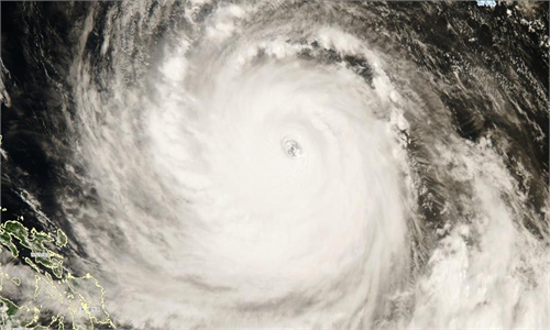
Ma said Bavi is among the most powerful and largest storms seen this year. Its maximum central wind speed has reached grades 16-17, while its cloud circulation has a diameter exceeding 1,000 kilometers and approaching 1,200 kilometers at its peak. The storm has maintained super typhoon intensity for nearly five days, featuring a well-defined eye, developed spiral cloud bands and a highly stable structure, he added.
Ma noted that Bavi's exceptional strength and long duration have resulted from multiple favorable conditions. The storm has passed over waters with high sea surface temperatures, providing abundant energy for its development. Meanwhile, plentiful moisture and a strong southwest monsoon have continuously supplied water vapor, while weak vertical wind shear and limited external interference have helped maintain its stable structure.
Authorities also called for advance deployment of emergency communication teams, state-owned enterprise engineering rescue forces and power supply support teams to prepare for possible extreme scenarios involving disruptions to transportation, power and communications.
Bavi's large size and abundant energy mean its remnants and outer rainbands could move from Jiangsu and Anhui provinces toward the Bohai Sea region after landfall, Ma warned. The storm may also penetrate inland and establish a northward channel for moisture transport. Not only eastern China, but also central, northern and northeastern regions should closely monitor its potential impacts.
"Compared with the southern regions, northern China has less experience dealing with typhoon-related strong winds and heavy rainfall. Therefore, areas including Anhui, Henan, Shandong, North China and Northeast China should strengthen preparations," Ma added.
RELATED ARTICLES