China has actively shared monitoring data to support Nepal's relief efforts: Nepalese expert
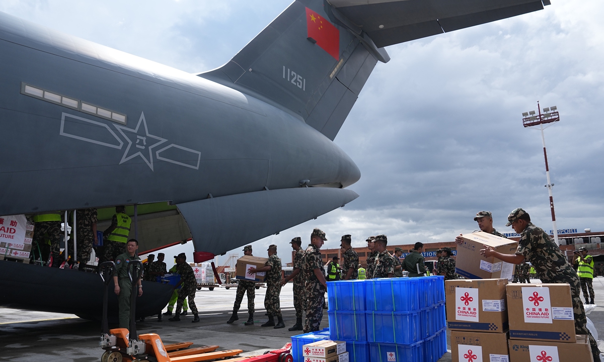
Nepali soldiers unload emergency relief supplies from a Chinese People's Liberation Army Air Force Y-20 transport aircraft at Tribhuvan International Airport in Kathmandu, Nepal, on September 3, 2026. The aircraft delivered China's third batch of emergency aid to Nepal, while 10 DNA forensic experts arrived on the same flight. Photo: VCG
While some western media have smeared China's "non-cooperation" in the August 26 Nepal mudslide, a Nepalese expert told the Global Times that Beijing has actively shared monitoring data to support Nepal's relief efforts, as the disaster exposed starkly divergent impacts on the two sides.The mudslide, triggered by a high-altitude glacier collapse in Nepal, struck Gyirong Port on the China-Nepal border in Southwest China's Xizang Autonomous Region on August 26. Chinese rescuers have launched all-out efforts to reach the mudslide-hit port area in their search for the missing.
As of Wednesday, 21 people had been confirmed dead and 541 remained missing on the Chinese side. In Nepal, 1,118 bodies had been recovered, with another 4,858 people still unaccounted for.
Drawing on his professional expertise and frontline information from Nepal, Amod Mani Dixit, founder of the Nepal National Society for Earthquake Technology, senior geologist and disaster risk management specialist, and PIFI visiting scientist at the Aerospace Information Research Institute of the Chinese Academy of Sciences, told the Global Times that the resulting structural impacts manifested with stark asymmetry between the two nations.
According to him, on the Nepali side, from the international confluence, the debris flow entered Nepal entirely, morphing into a systems-level catastrophe.
Critical regional infrastructure has suffered near-total failure: all hydrotechnical installations and bridges along the Bhotekosi and Trishuli corridors have been either completely washed away or structurally compromised, knocking out over 700 MW of hydropower capacity and severing dozens of vital motorable and suspension bridges.
Given China's economic resilience, technological edge, and robust scientific capital, its reconstruction is poised to be rapidly self-reliant; conversely, Nepal will require substantial international strategic and financial assistance to support its national rehabilitation efforts.
Dixit supposed that relief priorities are threefold: restoring logistical lifelines by deploying modular Bailey bridges to reconnect isolated border communities cut off by destroyed infrastructure; upgrading shelters from flimsy tarpaulins to insulated tents to protect survivors from the harsh alpine climate; and deploying tactical communications, as regional telecoms are paralyzed and only a few HF radios remain operational.
In this instance, the comprehensive scientific analysis provided by the Chinese scientific community proved instrumental in helping Nepalese authorities and the public understand the trigger mechanics of the disaster.
However, some Western media attempted to smear China by questioning whether China shared information in a timely manner and cooperated fully in this cross-border disaster.
In Dixit's view, in the immediate aftermath of the disaster, two prominent misconceptions skewed public perception.
The first is the "source fallacy." Because the majority of Nepal's major river systems originate in China's Xizang and flow southward, there was an erroneous assumption that this debris flow must have been triggered within Chinese territory. In reality, the collapse originated entirely on the Nepali side of the Langtang Himal.
The second is the "typological error". Public discourse and several non-specialist commentators immediately categorized the event as a Glacial Lake Outburst Flood (GLOF). This led to the false narrative that Chinese monitoring systems had failed to report a glacial lake dam failure. Because cryology remains an underrepresented specialization among Nepali engineering and scientific circles, the wider community reflexively defaulted to a GLOF diagnosis. This analytical vacuum allowed unverified rumors regarding a breakdown in cross-border communication to circulate briefly, Dixit said.
Bilateral communication channels remained intact and functional throughout the crisis, the expert said.
In the wake of the disaster, China's meteorological, water resources and other authorities have conducted close cooperation with relevant Nepali authorities in sharing monitoring information and disaster response, Foreign Ministry spokesperson Guo Jiakun said at a regular press briefing on Thursday.
The third batch of emergency relief supplies from China to Nepal has been sent this morning, including tents, blankets, mortuary refrigerators, medical protective suit and satellite communication equipment, Guo said.
A joint research team led by the Institute of Tibetan Plateau Research under the Chinese Academy of Sciences has made new progress in studying the mechanisms behind the disaster, explaining why the devastating Nepal mudslide occurred, and what caused it to intensify so rapidly. One of the key findings was that the scale of the eventual destruction was determined not only by the volume of the initial collapse, but by the substantial entrainment of additional material as the debris traveled downstream.
To promote multilateral disaster risk reduction cooperation across the Himalayan region, Feng Chaoyang, from the Chinese Research Academy of Environmental Sciences, previously told the Global Times that China could also act as an experience provider, institutional promoter and capacity builder through data sharing, institutional co-construction and joint project implementation.
Scientific foundations and technical standards could be shared, and institutionalized multilateral coordination mechanisms should be built on existing platforms to clarify responsibilities in data sharing and emergency response, with pilot cross-border watershed committees enabling real-time pre-disaster warning instead of passive post-disaster reaction, Feng said.
He noted that the cross-border joint prevention mechanism should be established to overcome administrative boundaries, integrating hazard surveys, satellite monitoring, ground-based observation and cross-border data sharing into a real-time coordinated early warning and emergency response system.
RELATED ARTICLES